 |
| Climbing from the parking lot on Rt. 311 |
It is hard to imagine another section of trail that the RATC covers that could be more spectacular than this hike. In fact, I haven't found any section of trail anywhere in Virginia more scenic than this one. While everyone seems to say that Mt. Rogers is the best hiking in Virginia, I think McAfee's Knob and Tinker's Cliffs are the best. In fact, Virginia has a rendering of McAfee Knob on its A.T. license plate.
It is said that McAfee Knob is the single most photographed spot on the A.T., and I can see why. It is really a breathtaking spot.

This is also a very popular hike, and, though we didn't see many folks on the day we hiked, the wear on the trail was evident. A Tuesday in mid-February is a good time to see the sights without encountering many folks.
We left the large parking lot on Route 311 at 9:12 AM, and 27 minutes later passed the first of three A.T. shelters we would see on this short section of trail, the John's Spring Shelter. Mike told me about the RATC's problem a couple of years back with a young fellow from Lexington who liked this area so much he basically moved in on weekends and kept his tent up when he was back home. They had to drag his tent and all of his stuff back to the parking lot, including quite a bit of electronics.
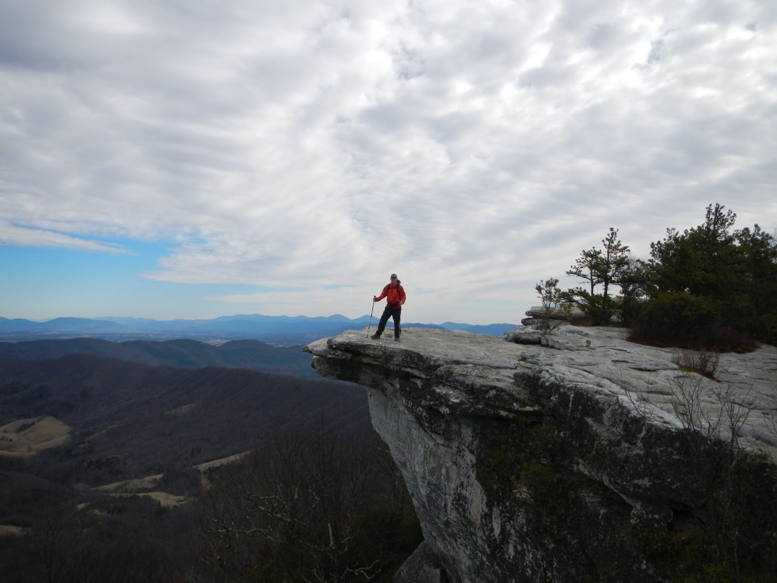 |
| Normal clouds look spectacular here. The ridge to the left of the rock was our route towards Tinker Cliffs. |
 |
| At McAfee, with North Mountain in the background. |
We projected to have a long hike, so we only stayed here for 10 minutes. And my colleagues told me that the view from Tinker Cliffs is actually better! So I was anxious to see what was next.
We took a short detour through a spot with large rocks called Devil's Kitchen before dropping to the Campbell Shelter at just under 5 miles. We snacked briefly here, and snacked again at a rocky spot with a nice view to the east at the 7.25 mile mark. At 8 miles we dipped to meet the Brickley Gap Trail, which bypasses Tinker Cliffs in favor of a straight shot to the Lambert's Meadow Shelter with little of the elevation gain climbing to Tinker.

 |
| The trail sometimes hugs the edge of the cliffs. |
 |
| Another tourist photo! |
 |
| Hiking along the cliffs' edge. |
 |
| The view southeast from Tinker Cliffs. McAfee Knob is the highest point on the left side of the photo. |

Bottom line: This is quite a hike! Highly recommended.
Hike Details.
PATC Difficulty Factor 323.9
Distance: 13.4 miles
Total Time: 6 hours 40 minutes.
Lowest point: 1333 ft.
Highest point: 3225 ft.
Total uphill: 3929 ft.
Very nice indeed, McAfee Knob reminds me a bit of the "Old Man of the Mountain" in NH....quite the landmark.
ReplyDeleteHello! My husband and I were planning on doing the full "Triple Crown" backpacking hike (35miles in 3 days with a 4.75hour drive on the 1st and 3rd days) until we started getting nervous that 10-13miles a day would be too much, especially with the shorter days we have with this season. We are going next week over Thanksgiving. After reading your blog, and seeing that you did 13miles in under 7 hours I am more convinced that we will be able to handle it! We are in our mid-twenties, both physically fit. I did a Mt. Rogers/Grayson Highlands 3-day, 21-mile hike a month ago as my first backpacking hike, and my husband has done marathons with a ruck sack. Do you think the Triple Crown is do-able for the two of us with the shorter daylight time of late November and this colder weather?
ReplyDeletenice post
ReplyDelete