Wednesday, September 27, 2017

Greenwood Point Trail, GWNF

The Greenwood Point Trail is located nearly on the West Virginia border, along Lake Moomaw, north of Interstate 64 and south of Virginia Route 39.  The best access from Charlottesville is to go west of Staunton to Rt 42, take that to Rt 39 in Goshen, and take 39 almost to West Virginia before turning south on Rt. 600 to the Bolar Mountain Campground, location of the trailhead.  The drive is about 2 and a half hours from Charlottesville. See the map at the end of this posting.

I took my scout troop out here in mid-September for a backpacking trip, sight unseen.  It was an ideal location for the troop, as the hike was about 3.5 miles each way, with some fairly strenuous parts and some nice views, and a large lake near the campsite. The hardest thing about the hike was figuring out where to pay for our campsite!

Because we camped in mid-September, we went out of season.  Two of the three campgrounds were closed for the season, and it was difficult to figure out how to get vehicle passes to leave in our cars. What you have to do is drive to the marina, which is still open, and pay for the passes there. The cost was incredibly low!  It cost us a total of $8 for the troop to camp at Greenwood Point, and to obtain six vehicle passes.  We parked next to Bolar Campground #3, at a turnaround area just a few sites away from the trailhead.

Although there is less than a 400 foot elevation gain between the low and high points on this trail, it is a surprisingly tough trail.  This is because most of the elevation gain and loss is right in the middle of the route.  On the way out to the campsite, you climb up to a vista, then drop steeply to a dry creek crossing before ascending briefly but very steeply again. The trip doesn't seem as steep on the return. It was very easy to follow the entire way and was not at all overgrown.

As you come to the Greenwood Point Campground, you leave the woods and come out into an open area.  The first thing you cross is an old macadam road, which predates the lake.
This map shows two editions of the USGS Topo - one before the lake and one after. 
The campsite is just below the former Perkins Point landmark.  
As you can see, a road went through the area prior to the lake filling in.
There are some old signposts, then several campsites scattered around the area.  One is near the water to the left. Two are to the right where the woods and the field meet.  And one is far to the right on the lake shore.  When we arrived, both lakeside campsites were taken, but the interior sites were bigger and worked better for our group.
Our campsite was in the trees, just south of a small open field.
There was a picnic table, a couple of fire rings and a tent pad in each of the
four campsites we found.
The lake was low, but I am not sure whether this is due to dry conditions or officials draining off part of the lake at the end of the season - or both. The boys enjoyed the fishing at the lake though the group did not catch many fish.  One boy who did catch a fish reported doing so using a large lure he found at the site. Fishing and dropping rocks into the lake kept the scouts entertained, and most reported liking this campout better than the backpacking campouts on the Appalachian Trail, our usual destination.
There were also a couple of old privies near our campsite.
I was glad I didn't need to use one!  The scouts who did
called them "dark," but they still beat digging a hole.

This shows another campsite closer to the beach on the north end of the field.


This was our "beach" on the northern end of the peninsula, right where the road would have submerged into the lake.

Morning shot from the beach looking northeast.
Autumn starts to encroach on the trail in mid-September.

Adult leaders bring up the rear when backpacking.

Group shot of the scouts.


Wednesday, September 6, 2017

Two Lick Trail, West Virginia

The Two Lick Trail is a five mile loop trail that starts and ends in the Monongahela National Forest's Pocahontas Campground, only a couple of miles west of the Virginia/WV border near Lake Moomaw.  You get there by taking WV 92 either north from White Sulphur Springs or south from Virginia Route 39 just after it crosses the state border.  It is only a few miles south of 39 near Rimel, West Virginia.  Trail Map.  I was out this way for other reasons, had a couple of extra hours, and decided to check it out.

The trail starts next to a map kiosk in the day use parking lot, which is before the campground loop. Park here and the trail curves around to a nice bridge over Two Lick Run after 100 yards.

A few hundred yards later, the trail forks.  I took the trail counterclockwise, so I cut to the right here. There was another sign shortly after that, for the Two Lick Bottom Trail.  Because the Bottom Trail starts and ends at the Two Lick Trail, you can choose either one and make the loop; I chose to stay on the original trail.
 The Two Lick Trail then crosses another bridge before gradually climbing the mountain through open hardwoods.

After only a mile, the Two Lick Trail intersects with the other end of the Two Lick Bottom Trail.  You could take this back for a really short loop, or keep going on the Two Lick Trail for more ascent and a longer loop.
 I kept ascending.  The trail was wonderful for its solitude and late summer vegetation.
Unfortunately, all the climbing really didn't pay off.  The trail never summited the mountain - which would have had me at the state border.  Instead it turned and rode the ridge below the summit.  I think this is because, back when the trail was originally constructed, there was a road at the ridgetop, and it was decided to keep some distance from the road.  But it means there wasn't much of a view, other than the limited view shown below, reached at the 2.4 mile mark, just after the high point on the hike.
The only view.
The trail hugs the side of the slope at its highest point.
On the way back down, the trail crosses an old woods road, which the USGS topo map indicates continues up the mountain to the road on the summit.  But the old road bed was overgrown with late summer vegetation.  It did not look like anyone uses this route. 
The trail goes under a massive Chestnut Oak.
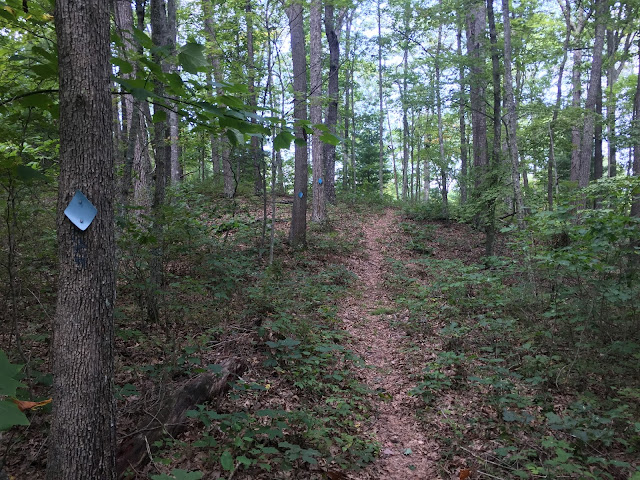
The trail was in nice shape - very well maintained and generally was prolifically blazed with plastic blue diamonds.  In fact the photo below had me thinking whether someone was paid by the diamond - there is no way to lose the trail here, with three diamonds over a space of 25 feet!

The campground is a pretty spot, with nine sites, pit toilets and waste cans.  The hand pump looks disabled, so there appears to be no water available here.  The Blue Bend Campground, also in the national forest but about a half hour south, is a superior choice for a weekend adventure.  It also has a five mile loop trail (into the Big Draft Wilderness), has showers and flush toilets, river swimming, picnic shelters, and access to the nearby Greenbrier River Trail for biking.