Monday, March 30, 2020

Sugar Run Trail - GWNF

The Sugar Run Trail is one of a series of trails climbing Shenandoah Mountain in the Bother Knob area, between Reddish Knob and US 33 west of Harrisonburg, Virginia. Although the bulk of this trail is in West Virginia, the lands hiked are maintained by the North River Ranger District of the George Washington and Jefferson National Forests.

Sugar Run Trail offers nice views and a big workout, climbing 2440 feet over a distance of 4.9 miles. The trail is also open to mountain bikers and equestrians, and is a popular route for bikers coming downhill at fast speeds. Be alert.

Vehicular access to either end of this trail is difficult:

  • The eastern end is accessed via a rough jeep road (FR 85-4).  Because there is no parking at the trail's end, this hike description will start where FR85-4 splits from FR 85.  Even FR 85 is a tough drive after it leaves SR 924, Briery Branch Road, though I saw a driver in a Pontiac sedan navigating it.
  • The western end is accessed via an unmarked side road off of Little Fork Road, which requires a stream ford before entering into National Forest land.

This hike description starts at the top of Shenandoah Mountain.

Mile 0.0: I parked just up the jeep road from where it splits off of FR 85.  There is a large spot off of the road here, and a campsite another 50 feet up the jeep road that can be a vehicle turn-around.  Walk north on the jeep road, reaching the hike's highest point a half mile up that road: 4170 feet elevation.
Parking spot on jeep road.  FR 85 can be seen at the far end of the jeep road.

Campsite just off of FR 85.  Vehicles can turn around here.

Visual evidence of why I would not drive the jeep road.

Mile 0.7: Pass trailhead for Bother Ridge Trail, #1026.  This is a shorter trail to the west that could be part of a long loop hike involving some road walks.  To the right here is an unblazed trail that ascends to the summit of Bother Knob - at 4344 feet elevation, the site of a former fire tower. Also up there is the Shenandoah Mountain Trail, #1024, which continues north to the High Knob Fire Tower and U.S. 33 (Link).
Looking at Bother Ridge Trail from the jeep road.  The Forest Service sign indicates hiking only,
but Trails Illustrated map designates this trail as multi-use.

Mile 0.8: Reach trailhead for Sugar Run Trail, marked with a metal trail sign indicating multi-use and starting out as an ungated woods road that drops away on the left from the jeep road.  Follow the trail, leaving the jeep road.

Mile 1.2: The road ends at a spring with a small campsite next to it.  It would appear that the road was created to access this spring.  Passing this spot in late March, a large mass of salamander eggs are visible in the pool created by the spring.
Campsite along trail.  Spring can be seen on the left.

Salamander eggs.
Mile 1.5: The trail crosses onto a small ridge, which it follows for the next couple of miles.  At first, the ridge is somewhat level. Along the way are valley views, including the large white antennas at the Sugar Grove Naval Radio Station.


Sugar Grove Naval Radio Station seen through the pines.
Mile 2.2:  Reach a small set of rocks, after which the trail drops steeply.  There are several short, steep drops along this ridge as you continue to drop in elevation.
Steep Drop occurs after these rocks.
 Mile 3.6: The trail switches back sharply to the right and drops off of the ridge.  It descends the side slope down to a stream known as Sugar Run.

Mile 3.8: The trail reaches an old road at 2140 feet elevation.  Take note of where you are if you plan to return back this way: there is no trail sign here, and the point where the trail meets this road is marked only by a faded yellow blaze on a tree.  Follow the road to the left, and shortly afterwards, you cross Sugar Run.


Mile 4.4: Cross a woods road.  This road could be used for part of a circuit hike with the Bother Ridge Trail if followed to the left here.  The Sugar Run Trail continues straight ahead through a gap in the trees and through a field.
Cross the road, then head straight into the field.
Mile 4.8: The trail comes close to Sugar Run again.  Across the stream is an example of an apparent anticline - an arch like bend in rocks with older rocks in the center.

Anticline seen along Sugar Run.
Mile 5.0: Cross a stream and then come to a dirt road and two large campsites on the right.  These are also parking areas for vehicles coming to the western trailhead from Little Fork Road.  The trail technically ends here.  Continuing down the road, you will encounter private property on both sides. 

Mile 5.4: Reach Little Fork stream, just before the main access road.  Vehicles driving up this road to park here will need to ford the stream.  Turn around here.
Little Fork stream with the Little Fork Road a few feet up the hill on the other side.

Mile 7.0: The trail leaves the woods road here.  You will have just crossed Sugar Run and will see a level area that could be a great campsite on the left.  Look carefully to your right for a faded yellow blaze signalling the trail's start up the ridge.  As you start to climb, you may notice a deeply rutted track that heads straight up the mountain.  This is not the trail - the trail climbs much more gradually along the side of the slope.  It is damage created by mountain bikes going off trail.
Campsite, looking left from the road. Sugar Run is further left, over the small rise.
Damage from mountain bikes is evident here.  The actual trail climbs the side slope to the right.

A faded yellow blaze and some compressed leaves subtly signal the trail leaving the woods road.
Mile 10.1: Reach the jeep road again after gaining about 2150 feet from Sugar Run over the past 3 miles.  Although the ascent is steep, winter views along the trail are nice.  It may even be possible to see the High Knob Fire Tower during the ascent, using a small scope.

Mile 10.8: Return to your vehicle.

Elevation Profile:

Monday, March 23, 2020

Mill Mountain Trail, Part 2

The Mill Mountain Trail is found in Augusta, Rockbridge and Bath Counties - between Deerfield and Goshen, Virginia.  It is an 8.5 mile point-to-point hike that I completed over two hikes.  The south end of this hike I completed first and reported on earlier in this blog (Link).  Interestingly, that is the only part of the hike actually traversing Mill Mountain.  The northern portion is on the higher elevations of Sidling Hill.

The north end is accessed from a forest service road called Clayton Mill Road.  There's a small wood sign on the road here that points down a side road.  I parked on Clayton Mill Road and was glad I did - there was only one turnaround spot, and the road ended at a stream crossing.  I'd rather stay along the main road with my vehicle.

Trail sign on Clayton Mill Road.
Begin by following the side road until it ends at the stream.

Cross the stream and the trail starts heading uphill using an old road bed.  The road bed ascends to a point where there is a rock cairn at the 0.8 mile mark.  The cairn has a yellow arrow pointing right because another, unmarked trail continues straight.  (This trail rides the ridge of Sidling Hill north to the Sam Judd Ramsey Trail.  And it is in better shape than the Sam Judd Ramsey Trail!)


Take a right at the cairn, and begin a gradual downhill before beginning a gradual uphill to the the ridge of Sideling Hill. Along the way were views of Jump Rock through the trees.


I reached the ridge at the 2.5 mile mark.  At this point, I left the trail to cut north along the ridge on a social trail to the next summit to the north.  I had GPS coordinates from a website saying that the summit was the site of an old fire tower.  But I could not find any evidence of the tower, despite spending several minutes searching around the coordinate.

So I headed back south, rejoined the blazed trail, and started up another slope, disappointed there was no evidence of a fire tower.  But as I climbed again, it occurred to me that there was no access road to the tower location.  It seemed more likely that I had the wrong coordinate when I looked up towards the summit of the slope I was climbing, and saw that the summit was covered with pine trees.


Not sure what it is about pine trees, but I often see them around old fire tower sites.  When I got closer, I came across some kind of well, shown below.  At this point, I knew that I had the wrong coordinate for the tower and that it was actually on the top of this summit.  (And, I had wasted a lot of time at the last summit.)


About 20 feet away were the concrete blocks that formed the base of the old fire tower, at 3060 feet elevation. So the actual coordinates are N38° 04.332' W79° 29.604'.


I tried giving the new coordinates and a photo to the website, but couldn't get it to work.

Continuing south, I dropped off the summit and came to a wide, flat area that would make a good campsite. 


At the south end of that area was the "money spot" on the entire trail - either day's hike - the reason for the effort.  There, I found a rocky overlook with views east to the Calfpasture River, Jump Rock and across to the Blue Ridge, including Bald Knob, Rocky Mountain and Cole Mountain.  


From there, the trail cut through another small pine forest, then started to drop to the point where I ended the hike when I started on the south.  The trail cut through a wide area that felt like I was walking through a boulevard.


The trail then cut through a rocky area that appeared to be the end of the access road coming from the south.  The trail became that road again, though parts of the road were pretty overgrown, as shown below, where two tire tracks are barely visible in the overgrowth.


The trail then entered into a forest that had clearly been thinned. Here, there were great views of mountains to the south, including Brushy Mountain, which the AT climbs over south of Roanoke.


I dropped down to the point I had reached from the south before returning north again and retracing my steps.  I hiked about 5 miles each way.

Knowing what I do now, I'd do this hike from the south.  Access is easier (the trailhead is just off of Virginia Rt 42), and if you get past the confusing part 1/2 mile from the southern trailhead, the hike from the south is more interesting.  

Highlights from the south:

1.5 miles: Overlook from Mill Mountain
2.5 miles: Trail Drops off of Mill Mountain
3.2 miles: Trail Crosses Ingram Draft
5.9 miles: Best Overlook
6.2 miles: Former Fire Tower Site.  Turnaround here.
12.4 miles: total distance.


Sunday, March 22, 2020

Little North Mountain Foot Trail

Driving south on Virginia Route 42 in Augusta County, after passing through Buffalo Gap and past the turnoff for the Old Parkersville Turnpike, but before reaching trailheads for Falls Hollow and Elliott Knob, you may notice a trail sign on the left side of the road.  It highlights a short trail that climbs Little North Mountain towards Kings Gap in far northern section of the Goshen-Little North Mountain Wildlife Management Area.


This sign has piqued my interest in the past, as it represents a trail that is not found on any maps I've looked at.  Back in March, 2017 I stopped to check it out.  The trail climbs to the nearby railroad tracks.  But on the other side of the tracks, there is no blazing, no signs and no trail that I could find.  There is a woods road on the other side of the tracks, and I followed it in each direction looking for the trail, without success.

For three years I drove past on my way to other trails and wondered what the deal was with a trail that has a sign along the highway, but could be followed only for several hundred yards before disappearing.  So, when looking for a new trail to hike in March, 2020 - three years later - I decided to hunt down this trail.  I found it, following these steps.  Below is that story, and the directions for others to use the trail.

I'm familiar with Kings Gap.  On the east side of Kings Gap is Camp Shenandoah, the local Boy Scout camp - my son's troop camped there many times. A trail connects the camp with access to Elliott Knob, on the west side of Virginia 42.  The trail cuts over Little North Mountain right at Kings Gap. It starts as a trail in the scout camp, merges into a road near Kings Gap on the east side, and follows that road for a while on the west side before turning off as a trail again and crossing Route 42 at the trailhead for the Falls Hollow Trail.  I had hiked to the falls several times without ever noticing the white blazes across the road signalling a trail on the east side.

Parking at the Falls Hollow trailhead, I followed the trail to the top of Kings Gap then turned north on a woods road, looking for the Foot Trail from the other end.  I marked the site of the sign pictured above in my GPS, and when I was about even with the waypoint as I worked north, an side road came in from the east. I took the side road.  Wrong move.

The side road died out, so I went off trail up to a ridge and bushwhacked north until I crossed a trail.  The ridge petered out and I dropped down to a gap formed by a stream.  As I came to expect when traversing the rough terrain, I found a trail when I dropped down to the stream.

Taking the trail west, it came out at an old road that parallels the railroad tracks.  There is a big sign here.

So, to take this trail, leave Route 42 at the sign for the foot trail.  Head up the slope and cross the tracks.  If you look at the photo below, the trail leaves the tracks heading north as following the yellow line..

Continue north on the road until you cross a stream.  Just after that is the sign for the trail.  Take this right.  The trail crosses the stream and continues towards Little North Mountain.

When it starts climbing, it climbs steeply through bushes, which are well cut back for the most part.


The trail reaches the ridge at 0.7 miles after leaving the old road.  There is another woods road here and a sign for the trail. (I would have seen this if I'd stayed on my original road before I had to bushwhack.)


Taking it left only leads to a dead end - I could not find any trails continuing past the end of the road.


So, instead follow the road to the right (south).  Along the way, there are nice views to the southeast, of the farmlands towards Camp Shenandoah and the Blue Ridge.


Continuing on the road takes you to Kings Gap.


To the left, a road heads down slope, and a trail takes you to Camp Shenandoah.  To the right, head down a different road following white blazes that will take you to the Falls Hollow trailhead.  Continuing straight continues along the Little North Mountain crest.  In theory, the trail continues along the ridge all the way to Jump Mountain, over 16 miles south.  I don't know for sure - that is for future explorations.

Thursday, March 19, 2020

Mill Mountain Trail (Near Goshen)

In the wake of the current pandemic, with the ATC advising everyone to stay off of the AT because of personal encounters, and the PATC advising everyone to refrain from trail work, I chose a trail I've never hiked out northwest of Goshen.  Figuring that few people hike it, I saw this as a great opportunity to practice some "social distancing."  I chose the Mill Mountain Trail, in the George Washington National Forest a little northwest of Goshen - in the northwestern corner of Rockbridge County.  There is no telling in advance what trails out this way will be like - I've hiked really nicely maintained trails, and I've hiked trails that haven't been maintained in 20 years.

Finding the trailhead was a little more difficult than it needed to be, thanks to the Nat'l Geo/Trails Illustrated Map #788, "Covington/Alleghany Highlands," which incorrectly shows the trailhead right off of the main road through the area, Virginia Rt. 42.  Instead, it is off of Rt 600, Big River Road.  The map should show 42 heading NE east of Panther Gap as 600.

This map also shows the trail starting at the back end of a gated forest road.  It actually parallels that road, starting from Rt. 600.  A downloaded .gpx track, which I placed in my GPS and used extensively during first part of this hike, proved much more useful than this error-prone map.  A link to the track is found later in this description.


The exact turnoff is FR 1596, which is permanently gated, as shown on the map with a black gate icon.  (Those open part of the year are orange.)  There is room for 3 or 4 cars to park here.

Looking from Rt 600 to the gate, you will see a trailhead sign on your left.  
The trail appears to be an old road, and it leads into a pine forest.  

There are houses on the left, and at one point it almost seems like the trail goes right through the yard of an occupied house.
After this house, however, the trail gets more secluded, continuing in a straight line through a pine forest.  After the pine forest ends, you find yourself in a little bit of a cove at about the half mile mark.  Following the yellow blazes on trees is important here.  I walked through a tree that had been cut and past an old blaze, and then saw nothing.  Fortunately, I had the trail's track loaded into my GPS and was able to find it after some searching.  But it took the return trip from the mountain summit to discover that the trail cuts left over the nearby ridge and follows a path half way down the other side of that ridge before climbing.  The photo below shows the route of the trail.  I went straight and continued straight until the trail cut back and crossed my direct line.
None of the rest of the trail was difficult to follow, and it looks like it had been expertly constructed decades ago.  
At the summit of Mill Mountain starting at the 1.3 mile mark, after a 1600 foot climb at a 14% grade, the trail walks along some large boulders, which adds to the scenic nature of the route.  
In between some of these boulders, 1.6 miles into the hike, is a nice opening to the east, where the Calfpasture River could be seen winding through the Marble Valley, and further away Little North Mountain with Jump Rock was visible.  It is possible that a nicer day would have also given views further east to the Blue Ridge and The Priest.

The trail followed the ridgeline until the 2.5 mile mark, when it cut left and began a gradual decline towards Ingram Draft.
Along the way was a medium sized forest inside a valley that is entirely within the National Forest boundary.  

The trail merged into an old woods road at the 3 mile mark.  It almost isn't visible on the way out, but returning could present some confusion as it appears that old road is maintained as a trail, presenting a Y intersection.  But the proper trail is the only one that is yellow blazed, so it is easy to follow.

At 3.2 miles, reach an intersection with a woods road that appears to still get a little use.  This is the Ingram Draft road, found on old topo maps.  There used to be a trail sign here, but now the post is all that remains.  

Continue straight ahead here following the yellow blazes, on another old road.  Maps from the 1940's appear to show that this was an access road to an old fire tower, long gone now and located further up the mountain.  One source indicates that the tower was taken down in the 1950's.  Link.

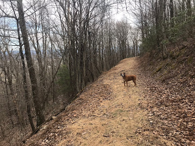
I did not go much further on this trip, choosing to turn around at a stream bed because my 4 legged hiking companion was having issues with a paw.  I never saw any campsites along the way, which leads me to believe that the trail's use is primarily from hunters.  And, although I could hear vehicles on Rt. 42 during the first part of the hike, after the trail dropped towards Ingram Draft, there was no external noise.  I felt totally secluded.  I plan to complete this trail in the future and was impressed with its condition.  Another seldom used gem!

For the rest of this trail, check out this post: Link.