Friday, January 29, 2016

Hiking Wildlife Watch: Salamanders

January is not the time to look for salamanders.  And truthfully, even in the Spring I am usually moving too fast on the trail to stop and look under rocks for these little creatures.  In nearly a quarter century of hiking Virginia trails, I've consciously seen them only a handful of times and bothered to photograph one only once.

But they always seem to be in the news!  I have gotten curious about them because it seems like every time some kind of construction project is stopped, it is because an "endangered Salamander" is behind the stoppage.

Cases in point:
  • The Cow Knob Salamander, an endangered species, caused the Forest Service to deny a permit sought to locate a natural gas pipeline near Ramsey's Draft Wilderness. (Link.) The article linked says the salamander wasn't even discovered until the 1960's. It is found only on Shenandoah and North Mountain of western Virginia and eastern West Virginia, and only between 2,400 and 4,300 feet in elevation. The Cow Knob Salamander is listed as a“Species At Risk” by the U.S. Fish and Wildlife Service, a “Species of Special Concern” in Virginia and West Virginia and “Near Threatened” on International Union for Conservation of Nature’s Redlist, according to Virginia Wilderness Committee.
  • An Ontario, Canada road is closed during parts of the year because of an endangered Salamander (Link).
  • In Texas, two legislators have gone so far as to introduce bills to prevent a couple of Lone Star State Salamanders from obtaining endangered species status, in order to keep the amphibian from affecting construction projects in that state.  (Link.)

So what is it about Salamanders?

Why does it always seem to be the salamander that is endangered?  It is a question I had wondered, but never pursued, until I came across the answer in a wonderful book I am reading.  I purchased The Forest Unseen because of the incredible reviews the book receives on Amazon.  It is about the author's observations of a small square of old growth forest land on a slope in southeastern Tennessee. The author returned to this spot many times over the year he wrote the book, and documented what he saw in wonderful prose. Each chapter is seldom more than 5 pages long - perfect for reading before turning out the light for the night.


The book is one that I have been slowly working my way through, as I savor each new topic author Haskell gives to me. Reading it in one sitting would not do it justice, though it is not a large book. The chapter entitled "February 28th - Salamander" gave me the "ah ha!" moment about salamanders. Haskell writes that adult salamanders "rarely stray more than a few meters; some individuals move farther downward into the soil than they do across the surface..." - as much as 7 meters below ground during winter. "Because they seldom move far, the salamanders on different sides of a mountain or valley are unlikely to interbreed." Over the eons, they evolve differently while adapting to the unique conditions of their particular environment. "The Appalachian Mountains are ancient rocks and...[parts] have never been covered by a killing sheet of ice-age glaciers. The salamanders here have therefore had time to explode in a burst of diversity that is unmatched anywhere on the planet." Many salamanders have evolved to the point that they don't even have lungs. "Evolution has discarded Plethodon's lungs to make its mouth a more effective snare.  By eliminating the windpipe and breathing through its skin, the salamander frees its maw to wrestle prey without pause for breath."

Salamanders therefore require moisture to keep its skin wet and breathe, following "cool, humid air like nomads, moving in and out of the soil as humidity changes." In summer, salamanders are usually found at night. Building a road or clear cutting a forest dries up parts of their territory, killing all salamanders there and separating salamanders from the rest of their territory. And salamanders, because they do not stray far, are very slow to repopulate a disturbed area. A 1988 study of the Cow Knob and Red-backed Salamanders (the latter a much more common species) on Shenandoah Mountain found no salamanders at one of their collection sites - where there had been a clear cut - attributing the animal's absence to the fact that "the lack of canopy cover prevented moisture retention."  Link.

So, it appears that Salamanders do not roam, which means that over the eons many different varieties have evolved among the ancient rocks of the Appalachians. And, because they require moisture to survive, they are very susceptible to changes in their immediate area, such as through logging or construction. (Ultimately, also, through climate change.)  That is why it always seems to be a salamander that is the endangered animal.

There are many different species of salamander in the Virginia mountains. The Department of Game and Inland Fisheries currently lists 48 species in the state (Link), and new species are not unheard of. Seventeen are from the family Plethodontidae, which are the lungless salamanders - out of 55 species currently known worldwide. (Other types of Virginia Salamanders include those known as "red salamanders" or "mud salamanders," those known as "dusky salamanders," - which are also lungless, and I don't know what is different between the two lungless types, those known as "mole salamanders," and those known as "brook salamanders," "cave salamanders," or "blind salamanders.")

The most common salamander is the Red-backed Salamander (mentioned above). William Needham (who writes on natural history topics for the PATC Newsletter and maintains a wonderfully informative website - Link), reports that Red-backed Salamanders make up "about 94 per cent of the total salamander biomass. The reason for this is that they have evolved to tolerate the cold better than other salamanders."  Link.

Several of the Virginia lungless salamanders have "among the smallest ranges of any mainland vertebrates in North America." (Link.) These include:

  • Big Levels Salamander (Plethodon sherando), named after, and inhabiting, the region between Sherando Lake and the summit of Bald Mountain at the end of the Torry Ridge Trail known as Big Levels. It was first named only in 2004, well after I started hiking in this area.  They live above 2000 feet elevation (just higher than Sherando Lake) and are classified as "Vulnerable" because their range is so small. Link.

Plethodon sherando; Big Levels Salamander ©2015 Will Lattea

  • Peaks of Otter Salamander (Plethodon hubrichti), found in forest habitats above 2775 feet within a narrow 19 km long stretch of the Blue Ridge Mountains in Virginia near the Peaks of Otter (Petranka 1998).  Classified as "Vulnerable," also due to a small range. Link.

Peaks of Otter Salamander (Link)

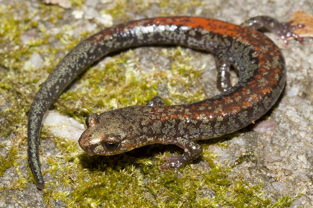
  • Shenandoah Salamander (Plethodon shenandoah), which is listed as federally endangered, is found in talus outcrops on three mountains in Shendandoah National Park - Hawksbill, Stony Man, and The Pinnacles. It is only found at elevations at elevations above 3000 feet and is confined to deep pockets of soil within the talus on the north and northwestern faces of these mountains in mixed-conifer forest.  The higher level of critical status is a result of this species' extremely limited range, and also due to greater competition than other salamanders listed with the more common Red-backed Salamander for territory.
Shenandoah Salamander (from Wikipedia)
So how cool is that?  Some of my favorite hiking areas near Central Virginia not only have great trails, but they are home to very rare and exclusive residents.  I have reason to go back to these areas in 2016, to see if I can witness some of these rare creatures.

Tuesday, January 26, 2016

James River Face Wilderness Winter Group Hike - Jan 14, 2016

The James River Face Wilderness is one of my favorite places in Virginia to hike.  In the past two years, I have journeyed here seven times for hikes in this wilderness, completing all mapped trails in the wilderness.  And because I lead hikes for both the Roanoke Appalachian Trail Club and the Potomac Appalachian Trail Club's Charlottesville Chapter, this is a great location somewhat mid-way between these two areas.

The really great thing about the JRF Wilderness is that every time I return there I find something that has me itching to return again to explore.  This place is like a proverbial onion, with layer upon layer of places to explore.  First, there was the Appalachian Trail.  Next there were the other official trails in the Wilderness, which ascend like wagon spokes from disparate locations outside the park to a central core at higher elevations inside the wilderness.  Now, I am excited to continue exploring trails that used to exist and are no longer recognized by the Forest Service.

On January 16, 2016, I led a group hike through the JRF. There were too many hikers for a single group, as Forest Service regulations limit a hiking party to 10 or fewer people, and we had 16.  So we broke into two groups and one group ascended the Sulphur Springs Trail, while the other (my group) ascended the Petite's Gap Road and entered the JRF on the old Sulphur Ridge Trail.

This is a great time of year to use the Petite's Gap Road as a hiking trail.  The Blue Ridge Parkway was closed due to ice, which meant that Petite's Gap Road was a dead end.  We could tell from the undisturbed snow on the road that no vehicles had passed by our starting point, so we were safe from vehicles uphill of our hike.  Since we parked at the trailhead for the Sulphur Springs Trail, our first 2.2 miles was hiked on the Petite's Gap Road.

Hiking the Sulphur Ridge Trail.
The Sulphur Ridge Trail leaves the Petite's Gap Road at the same place that the Glenwood Horse Trail leaves the same road, headed in the opposite direction.  You have to know what you are looking for, but it isn't too hard, as the road takes a hard left right at this point.  I took the group in this direction because I wanted to make sure the group made this critical turn, and a couple of the speedier hikers in our group almost missed it.  The trail shows up on the USGS topographic map, but not on any current trail maps because the Forest Service doesn't want it included on maps.  I have previously described this trail here: Link, and included a video so you can see how nice it is.

Despite not being on the current list of trails, this old trail is in good shape and has a gentle grade.  I chose this loop for the group's hike because there is not a steep grade in the entire hike, and it is a great way to easily ascend to the upper reaches of the wilderness.  It is slightly steeper if you hike it counter-clockwise, taking the Petite's Gap Road first, than if you start off hiking the Sulphur Springs Trail.

We hiked the old Sulphur Ridge Trail until it ended at the Appalachian Trail - where that trail takes a sharp turn.  We left a pink marking ribbon here so that the group hiking in the opposite direction wouldn't miss this turn, but it really wasn't a problem, as there was a dusting of snow on the ground and no footprints on the A.T.  In fact, we never saw evidence of another hiker in the wilderness all day.  The other group followed our footprints and knew when to turn off of the A.T.
The site of the former Marble Spring Shelter, along the A.T.
Both groups met for lunch at the site of the old Marble Spring Shelter.  A shelter was originally constructed of wood and tarpaper here in 1933, but it was destroyed twice - first by a bear and next by "vandals." After JRF became a federally designated wilderness in 1976, the first such wilderness in Virginia, the latest shelter was disassembled and moved south where it still exists on Cove Mountain. There is no real sign of the shelter today, only a flat spot with a fire ring.
2012 photo of Cove Mountain Shelter, formerly the Marble Spring Shelter.
The group gravitated to the east, down below the crest of the saddle where the shelter used to sit, as the wind was cold.  I never got around to lunch because the old shelter location is also the endpoint of an old trail that connected to the Blue Ridge Parkway. At the shelter site, there was a dusting of snow, and as a result, the old trail nearly lit up in the woods - its location showed up very clearly, as you can see from the photo below.  This trail is no longer on maps, but older topographic maps show its existence. The 1950 edition of "Guide to Paths in the Blue Ridge," the precursor to today's ATC Appalachian Trail Guides, describes the trail as follows: "Forest Service Trail leads .8 m. to Blue Ridge Parkway at 4.6 m. from U.S. Route 501 and 2.7 m. from Petites Gap; this trail continues 1.2 m. farther to Peters Creek Road." The trail is also described in the 1974 edition of the "Appalachian Trail Guide: Southern Virginia," but here it is "an unblazed trail" that "leads 0.8 m. to the Parkway between mile posts 68 and 69." I need to go back to follow the old trail, now that I have located where it comes into the Marble Spring area. (For an update, check out this post: Link.)
Old trail to Blue Ridge Parkway from Marble Spring shows clearly in the
dusting of snow.
Old topographic map shows trail connecting BRP to Marble Spring.
After lunch, we continued northbound on the A.T. until we reached its intersection with the Sulphur Springs Trail.  We took a left onto that trail, which is really an old road.  Interestingly, this road is neither found on the old topo shown above, nor is it described in the 1950 trail guide.  Maybe it is newer than that guide and map.  It is described as a "fire road" in the 1974 trail guide.

Shortly after turning onto the Sulphur Springs Trail, we came to a rock which provides, for my money, the single best viewpoint of the entire JRF Wilderness.  The view is southwest down the valley we drove to get to this hike, and it looks like there has been no human activity anywhere, other than the road we hiked in on.
View from a rock on the Sulphur Springs Trail.
The Petite's Gap Road is visible climbing on the left-center.
The Sulphur Springs Trail dropped us gently down to our trailhead, and a few minutes after we arrived, the other group met up with us.
Group photo.
The two Charlottesville hikers headed north through Buena Vista, and we got lunch at The Meat Shack - the special was hot turkey, with a double shot of mashed potatoes and we nabbed the table closest to the fireplace.  Yum!  I can't wait to return.

Hike details.
PATC Difficulty Factor: 175.2 (this is really a pretty easy loop.)
Total Distance: 7.8 miles 
Total Time: 3.5 hours

Total Elevation Gain: 1957 feet 
Starting Elevation: 1470 ft.
Low Point: 1470 ft.
Highest Point: 2677 ft.
Difference: 1207 ft.

Like what you see?  Check out my other blog postings!  LINK.

Wednesday, January 6, 2016

Shenandoah National Park: Former A.T. Sawmill Run Shelter Site

According to a posting on Whiteblaze.net, an information portal for Appalachian Trail hikers, there are at least 7 shelters in Shenandoah National Park (SNP) that were torn down for unknown reasons in the 60's and 70's. According to one source, the list includes:
  • Elkwallow Shelter near Skyline Drive MP24
  • Shaver Hollow Shelter near MP 35
  • Hawksbill Gap Shelter near MP45
  • Lewis Spring Shelter near MP 51
  • Big Run Shelter near MP82
  • Riprap Shelter near MP91  (no doubt this one was deconstructed due to overuse in the area)
  • Sawmill Run Shelter near MP95
On the final day of 2015, I had one more hike in me, but did not want to compete with the occupants of the four bear trucks I saw at the National Forest trailhead my dog and I had planned to use.  I ended up instead in Shenandoah National Park on the Appalachian Trail, looking for the site of the former Sawmill Run Shelter.  The shelter and access trail are shown on USGS Topographic maps, but not on current hiking maps.  The PATC trail map shows a spring, but the National Geographic Trails Illustrated map does not - only a stream.

I ended up taking a short hike into the past.

As you can see from the topo map copied below, the access trail to the former shelter site is right at the point where the A.T. takes a sharp turn to the right when hiking northbound.  This is a great help, as one of the toughest things when searching for an old trail is finding the point where the former trail connected with the current trail system.  An experienced trail person once told me that old trails are only obliterated for a short distance, as when a former trail is not on a map and not evident from any current trails, usage drops to nearly zero.

That doesn't mean I found the trail very easily.  Right at this sharp turn, there are several trails heading off along Sawmill Ridge.  I had to hunt around in the woods for a while until I came upon the old shelter access trail.  I found it right at the switchback shown on the map.  
The trail was nicely cut out of the mountain, possibly by the CCC during the depression.
After I located the trail, it was easy to follow.  It was bordered by brightly colored moss and was in better shape than many of the national forest wilderness trails I have hiked in the past year. The trail led down to a slowly running spring, which feeds into Sawmill Run and the South River just north of Waynesboro.  (The South River merges with the North River to become the South Fork, Shenandoah River, just north of the town of Grottos.)

There is no sign of the old shelter - only a flat spot with a fire pit.  It must have been a small shelter, as there is not a lot of space at the former shelter's estimated location.  But it is an exceedingly peaceful location, and it was nice to sit for a while and contemplate all the folks that used this now isolated spot until about 40 years ago.  The site is not even listed as a campsite on the A.T. guides, likely because the National Park Service wants hikers to practice "Leave No Trace" dispersed camping, rather than trampling specific spots.
View from the shelter site looking towards a firepit and the stream location.


So what is the deal with the elimination of this shelter?  I asked the Potomac Appalachian Trail Club's Archivist. who told me that the "Sawmill Run shelter was brought into the system in 1941, and was closed/dismantled in 1984."

He continues, "The rampant misuse of the AT and shelters during the counter-culture revolution in the 1970’s led frustrated NPS officials to close shelters.  An SNP Superintendent in the 1970s finally closed all shelters, and did not reopen them for several years, enduring passionate protests from PATC president Ed Garvey.  The closure of Sawmill Run does not seem to fit into that timeframe, and my database does not show why it was closed.  1984 does not seem to synch in with the shelter closure, so it might be a misprint for 1974."  He later came back with an old photo of the shelter, from the PATC Archives.  Here it is:
Undated photo of Sawmill Run Shelter, from PATC Archives.

The moss almost glows at this time of year, making the trail very easy to find once close.
Another source says that shelters in SNP were removed for three major reasons.

1. The Federal Wilderness Act - some of these shelters were in areas designated as wilderness and were removed for that reason (he lists Big Run and Rip Rap Shelters.  I am not sure that Rip Rap was sited within wilderness boundaries, but Sawmill Run probably is).

2. Party sites (Elkwallow, Hawksbill Gap, Shaver Hollow and probably Lewis Spring).

3. Money - by removing the shelters they no longer had to patrol them or clean them up thus fewer calls on park resources.

Returning to the Appalachian Trail, the shelter access trail remains in good shape for its entire length, though I might not say that if I visited in July, like fellow searcher Bill Fawcett did (photos below).  

I didn't find the trail originally because I didn't look in the right place.  Hopefully the photo I have included with this blog posting will help you find the trail if you want to go out and check it out.  It is a short hike to a peaceful spot that was once much more used than it is now.  I recommend it as a spring access point, but not for camping as there isn't much room down there.


The A.T. continues to the right, where the dog stands.  I went to the left, between the trees - this was not the correct route. To get to the shelter, the old trail is straight ahead.
In summer, the old access trail is much harder to locate from the Appalachian Trail.
Photo courtesy of Bill Fawcett, taken July 14, 2014.
In summer, the trail is a green tunnel as it descends to the old hut site.  
Photo courtesy of Bill Fawcett, taken July 14, 2014.
I continued on to the nearby Turk Mountain summit for some views.
It really has nothing to do with the rest of the hike, but who doesn't like some great views!