Wednesday, December 6, 2017

Marshall Draft Trail

The point of this blog is to feature remote and obscure trails in Virginia, so that they don't fade into oblivion while 95% of the state's hikers rush to hike locations like Old Rag and MacAfee Knob multiple times.  This description highlights one of the more remote and obscure trails in the George Washington National Forest.

The Marshall Draft Trail climbs the west side of Shenandoah Mountain in Bath County.  I hiked it to access a section of the Shenandoah Mountain Trail I'd not yet explored, and to check out the site of an old fire tower.

My personal definition of a "remote" trail hinges on how long I have spent off pavement getting to the trailhead.  Under this definition, the most remote trailhead I've achieved is the western end of the Sinclair Hollow Trail, found on the west side of Ramsey's Draft Wilderness.  Arriving at this trailhead took over 90 minutes on dirt Forest Service Roads to reach, riding in a high clearance pickup truck because my Outback would not be able to handle the access roads.

Parking along FS 394 just north of the trailhead.
Trailhead sign is somewhat visible on the right.
The Marshall Draft trailhead is not quite as remote as that, but it is certainly among the top 5 most remote I have reached in Virginia.  From Charlottesville I drove 85 miles over 2 hours, including 7.5 miles (24 minutes) on dirt/gravel forest service roads to get to this trailhead. The trailhead is located on a twisty road (Sugar Tree Road - FS 394) off of another dirt road (Scotchtown Draft Road - SR 627) on the west side of Shenandoah Mountain in Highland County, Virginia.  The trailhead coordinates are N38° 10.242' W79° 32.544'.  Coming south from U.S. 250 is a little harder, because the turnoff from SR 614 is unmarked.  Heading south on SR 614, the turnoff onto FS 394 (here called Nelson Draft Road) is just south of SR 614's Cowpasture River bridge crossing.

View from the trail looking down at the parking area. 
The trail climbs steeply right from the start.


I hiked the trail during hunting season as I knew the access road would be passable.  Earlier in the year I attempted to reach the same trailhead but was thwarted by a tree that fell down across the entire roadway.

The trail itself is marked by a trail sign that had deteriorated to the point that 2/3 of the sign was rotting on the ground.

This decaying signpost marks the lower end of the Marshall Draft Trail.
This photo shows the Marshall Draft Trail ascending from the access road, then switching back a the double diamonds.

The trail deceptively switches back about 20 feet into the hike, takes a right turn about 100 feet later, and then climbs straight up the mountain.  It is deceptive because you won't again see a switchback over the entire trail! The first 4/10 of a mile climbs at a whopping 23% grade before moderating only slightly to an 18.2% grade over 7/10 of a mile.  In its 1.3 mile total length, the Marshall Draft Trail climbs from 2200 to over 3500 feet elevation.  Needless to say, it provides an incredible workout!
The Marshall Draft Trail ascends along the side of a mountain ridge.
It washes out a little about 2/3 of the way to the top, but generally is in great shape.

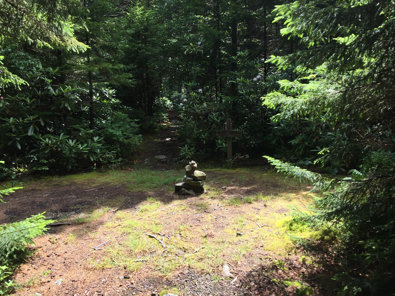
The Marshall Draft Trail (MDT) ends at its intersection with the Shenandoah Mountain Trail (SMT).  Keep a sharp eye looking at where you came from, as the MDT is much less evident than the SMT - the SMT gets a lot more use, mainly by mountain bikers.  See the photo below noting that both trails are marked by the same yellow diamonds. The diamond for the MDT is much harder to pick out on this photo. (Click on the photo to expand.)

This intersection is a saddle between two peaks on Shenandoah Mountain - Wallace Peak (3795 ft. elevation) and a higher peak to its northeast named, appropriately, Northeast Peak (3811 ft. elevation).  Wallace Peak is of more interest, described in detail below.

Also at this intersection is a potential camping spot, and a wildlife pond.

Wildlife Pond on Shenandoah Mountain.
 A road used to come up here from the east (along a stream with the wonderful name of "Jerkemtight Branch"), and maps now show the road permanently gated near its eastern end.  The road actually continued to the summit of Wallace Peak, and it must have been closed when the old fire tower on the summit of Wallace Peak was eliminated.

I was curious to see the summit, as I had heard that locals often hike up there.  Would there be a view?  It wasn't easy to find out, as it took me some time to find the road's location.  The access road isn't found on my trail map, and though it is obvious at lower elevations coming up from the east, it disappears near the wildlife pond.  I eventually found it - I am pretty sure the wildlife pond sits where this road used to be.  There is a large pine tree just uphill from the pond, and the road reappears just to the west of that tree - toward the SMT.


As you can see from the photo above, the roadbed becomes very obvious once you get away from the wildlife pond.  There is even a campsite in the middle of the roadbed about 1/3 of the way up from the pond.  It is about 3/4 of a mile each way to the summit and, though I found the base of the tower, there was no view to speak of up here.  It was an easy and obvious route to the summit, once found.
The rocks mark one of the concrete bases for the tower.

Panoramic view from the summit of Wallace Peak.
USGS Topo shows the location of the road to Wallace Peak.
Though it is no longer used, it was easily found once away from the intersection.
After returning from the summit, I headed north on the Shenandoah Mountain Trail.  I had hoped to link up with the intersection of the SMT and the Nelson Draft Trail, which I had reached earlier in the year on another hike.  It was a pretty dreary day, however, and a fine rain started when we were hiking north.  I gave up after completing about 2.3 trail miles north from the MDT, figuring I'd try again another day.  Upon returning home and downloading my GPS data onto my computer, I was surprised to see that I was still over 3 miles as the crow flies from my goal.  I am glad I turned around, as I might still be out there!

The Shenandoah Mountain Trail is a really long, remote trail.  It extends about 25 miles between paved road crossings and this portion of the trail goes for over 17 miles without road access of any kind.  It is a relatively popular mountain bike trail, and given its length, this makes perfect sense. The mountain biking community has had a profound effect on this trail, both good and bad.  The bikers are good for the trail because they clean blowdowns off of the trail - this trail would not be in nearly the shape it is in without them!  But they also use the trail when conditions are wet and their tire tracks form channels which cause "cupping" in the trail. Rain uses the trenches and erosion is hastened.

The Shenandoah Mountain Trail between the Marshall Draft Trail and the Nelson Draft Trail shows evidence of
mountain bike use: the slight downhill here has the trail forming a slight trench ("cupping")
which will further deteriorate the trail as rainfall runoff channels into the trench. 
This section could use a couple of water bars, which divert the rain off of the trail and downhill. 
Bikers hate this form of trail protection because it gets in the way of long coasts on bikes.

Before dropping back to the road, the Marshall Draft Trail gives this view west to Bullpasture and Jack Mountains
in Highland County.
It is interesting to note that USGS maps dating back to 1946 indicate that the Marshall Draft Trail used to continue past the road where I accessed it (as this road remained unbuilt on most maps).  The trail continued all the way almost to the town of Williamsville on the other side of the Cowpasture River.  The current trail is only about a third of the original trail, though the western portions of the trail are on private land.  I saw a trail continuing past the road, possibly to meet up with the original trail.  The road's construction blew away the portion of the ridge that the trail originally used.
The red in this map is my route.  The faint purple is the alignment of the access road, and the black dotted line
shows the Marshall Draft Trail continuing until meeting a rough road near the Cowpasture River.


Wednesday, September 27, 2017

Greenwood Point Trail, GWNF

The Greenwood Point Trail is located nearly on the West Virginia border, along Lake Moomaw, north of Interstate 64 and south of Virginia Route 39.  The best access from Charlottesville is to go west of Staunton to Rt 42, take that to Rt 39 in Goshen, and take 39 almost to West Virginia before turning south on Rt. 600 to the Bolar Mountain Campground, location of the trailhead.  The drive is about 2 and a half hours from Charlottesville. See the map at the end of this posting.

I took my scout troop out here in mid-September for a backpacking trip, sight unseen.  It was an ideal location for the troop, as the hike was about 3.5 miles each way, with some fairly strenuous parts and some nice views, and a large lake near the campsite. The hardest thing about the hike was figuring out where to pay for our campsite!

Because we camped in mid-September, we went out of season.  Two of the three campgrounds were closed for the season, and it was difficult to figure out how to get vehicle passes to leave in our cars. What you have to do is drive to the marina, which is still open, and pay for the passes there. The cost was incredibly low!  It cost us a total of $8 for the troop to camp at Greenwood Point, and to obtain six vehicle passes.  We parked next to Bolar Campground #3, at a turnaround area just a few sites away from the trailhead.

Although there is less than a 400 foot elevation gain between the low and high points on this trail, it is a surprisingly tough trail.  This is because most of the elevation gain and loss is right in the middle of the route.  On the way out to the campsite, you climb up to a vista, then drop steeply to a dry creek crossing before ascending briefly but very steeply again. The trip doesn't seem as steep on the return. It was very easy to follow the entire way and was not at all overgrown.

As you come to the Greenwood Point Campground, you leave the woods and come out into an open area.  The first thing you cross is an old macadam road, which predates the lake.
This map shows two editions of the USGS Topo - one before the lake and one after. 
The campsite is just below the former Perkins Point landmark.  
As you can see, a road went through the area prior to the lake filling in.
There are some old signposts, then several campsites scattered around the area.  One is near the water to the left. Two are to the right where the woods and the field meet.  And one is far to the right on the lake shore.  When we arrived, both lakeside campsites were taken, but the interior sites were bigger and worked better for our group.
Our campsite was in the trees, just south of a small open field.
There was a picnic table, a couple of fire rings and a tent pad in each of the
four campsites we found.
The lake was low, but I am not sure whether this is due to dry conditions or officials draining off part of the lake at the end of the season - or both. The boys enjoyed the fishing at the lake though the group did not catch many fish.  One boy who did catch a fish reported doing so using a large lure he found at the site. Fishing and dropping rocks into the lake kept the scouts entertained, and most reported liking this campout better than the backpacking campouts on the Appalachian Trail, our usual destination.
There were also a couple of old privies near our campsite.
I was glad I didn't need to use one!  The scouts who did
called them "dark," but they still beat digging a hole.

This shows another campsite closer to the beach on the north end of the field.


This was our "beach" on the northern end of the peninsula, right where the road would have submerged into the lake.

Morning shot from the beach looking northeast.
Autumn starts to encroach on the trail in mid-September.

Adult leaders bring up the rear when backpacking.

Group shot of the scouts.


Wednesday, September 6, 2017

Two Lick Trail, West Virginia

The Two Lick Trail is a five mile loop trail that starts and ends in the Monongahela National Forest's Pocahontas Campground, only a couple of miles west of the Virginia/WV border near Lake Moomaw.  You get there by taking WV 92 either north from White Sulphur Springs or south from Virginia Route 39 just after it crosses the state border.  It is only a few miles south of 39 near Rimel, West Virginia.  Trail Map.  I was out this way for other reasons, had a couple of extra hours, and decided to check it out.

The trail starts next to a map kiosk in the day use parking lot, which is before the campground loop. Park here and the trail curves around to a nice bridge over Two Lick Run after 100 yards.

A few hundred yards later, the trail forks.  I took the trail counterclockwise, so I cut to the right here. There was another sign shortly after that, for the Two Lick Bottom Trail.  Because the Bottom Trail starts and ends at the Two Lick Trail, you can choose either one and make the loop; I chose to stay on the original trail.
 The Two Lick Trail then crosses another bridge before gradually climbing the mountain through open hardwoods.

After only a mile, the Two Lick Trail intersects with the other end of the Two Lick Bottom Trail.  You could take this back for a really short loop, or keep going on the Two Lick Trail for more ascent and a longer loop.
 I kept ascending.  The trail was wonderful for its solitude and late summer vegetation.
Unfortunately, all the climbing really didn't pay off.  The trail never summited the mountain - which would have had me at the state border.  Instead it turned and rode the ridge below the summit.  I think this is because, back when the trail was originally constructed, there was a road at the ridgetop, and it was decided to keep some distance from the road.  But it means there wasn't much of a view, other than the limited view shown below, reached at the 2.4 mile mark, just after the high point on the hike.
The only view.
The trail hugs the side of the slope at its highest point.
On the way back down, the trail crosses an old woods road, which the USGS topo map indicates continues up the mountain to the road on the summit.  But the old road bed was overgrown with late summer vegetation.  It did not look like anyone uses this route. 
The trail goes under a massive Chestnut Oak.
The trail was in nice shape - very well maintained and generally was prolifically blazed with plastic blue diamonds.  In fact the photo below had me thinking whether someone was paid by the diamond - there is no way to lose the trail here, with three diamonds over a space of 25 feet!

The campground is a pretty spot, with nine sites, pit toilets and waste cans.  The hand pump looks disabled, so there appears to be no water available here.  The Blue Bend Campground, also in the national forest but about a half hour south, is a superior choice for a weekend adventure.  It also has a five mile loop trail (into the Big Draft Wilderness), has showers and flush toilets, river swimming, picnic shelters, and access to the nearby Greenbrier River Trail for biking.

Thursday, August 31, 2017

Cranberry Wilderness, West Virginia, July 2017

I was scheduled to take my Boy Scout troop to Mt. Rogers for a 3 day backpacking trip, but for a bunch of reasons it could not work out - most likely because it was set up kind of last minute. After discussing with the committee, we decided to backpack another weekend. My wife had made plans for the weekend that didn't include me, so I suddenly had a 3 day backpacking weekend last minute!  

Where to go?  I had been out to the Cranberry Wilderness ("CW") once, briefly.  Very briefly. Link. I had done 5 miles out and 5 miles back on the North-South Trail as a day hike, managing to get the hike in and be back in Charlottesville by 5 PM same day because everything went right.  I wanted to go back and see some more.

The CW is said to be the largest wilderness on the East Coast.  Within the wilderness is the most remote spot in all of West Virginia and though the wilderness does not have a lot of elevation change and has few overlooks, it has a reputation for difficulty.

I used a map I found online (Link) to plot a course, coming up with a nice large loop that would keep me moving much of the time and would have me out for three solid days of hiking. Some of the trails I would be using are described as less popular, which might mean a little solitude along the way.  
I took the route marked in red.
Routes marked in orange are the most popular in the wilderness.

I started at the Three Forks Trailhead on the northwestern edge of the wilderness about noon on Friday.  The trailhead was easy to get to and the roads were in great shape.  When I arrived, there were no other cars in the lot. For navigation I was armed with the map linked above, a second version I had created giving mileage between trail intersections, a compass (which I always bring and seldom need, but it doesn't weigh much...) and my trusty handheld Garmin GPS - loaded with a WV topo and an overlay called "My Trails" which is usually pretty accurate though not always, and includes most (not all) of the trails in the CW.
Empty parking lot at the Three Forks Trailhead, noon on a July Friday.
It was packed by Sunday.
Almost right away I had some trouble staying on the Little Fork Trail heading south from the trailhead into the wilderness.  I attributed this to three things - my feet got wet almost right away because my "waterproof socks" weren't; there are a ton of interconnecting old rail beds in this part of the wilderness, and this is a less used trail - remember that my car was the only one in the lot.
Many trails end at the Three Forks Trailhead.
Some are even maintained.

This stream crossing was almost immediate after leaving the trailhead.
My feet were wet for the rest of the outing.

But I was never too far off, and I used the My Trails overlay on my GPS to get back on the trail when the trail I was taking died, and I walked back downhill to reach the point where I messed up so I could figure out where I went wrong.  Further south, the navigating was easier, and by the time the Little Fork Trail ended at the North-South Trail, I was moving at a good clip.

One of many old rail beds in the northwest portion of the wilderness.

The Little Fork Trail ended at the North-South Trail.
After heading east on the N-S trail and then turning onto the Birch Log Trail and taking it until it ended at an old gravel road, I made it as far as the Tumbling Rock Shelter by 4:30 Friday afternoon without further difficulty.  This is one of multiple Appalachian Trail style shelters located just outside the wilderness boundaries along the South Fork Cranberry River, but seemingly still a long way from civilization. I was elated to find the shelter empty and set up dinner.  By the time I had eaten, it started raining hard off and on.  Even though I was stopping 5 hours before sunset, the idea of an empty shelter seemed pretty appealing.  I don't usually stay in shelters because I don't want to wake up as some mouse is running across my head (and my research indicated that this shelter has them). But I set up the tent in the shelter and never saw a mouse.  Or another person - all day Friday and not until about 11 AM on Saturday.

Tumbling Rock Shelter from the road.

South Fork, Cranberry River, from my campsite.

View from the shelter.

My mess.
Even so, I didn't sleep well - my fitbit records me waking 21 times - and by the time I was on the move again at 6:45 AM Saturday, I had hatched this plan that I might hike much of the way back to the car, overnight within three or four miles from the end of the trip, and get some additional trails in on Sunday.  I blame my lightweight mattress for my insomnia, which isn't as comfortable as I would like, and I knew that a second bad night would make for a tough drive home.  I estimated the total distance back to the car via the trails I wanted to take to be around 19 miles, well within my range.


I continued east on the road, past a wonderful campsite that was hard to see from the road, and quckly came to the Tumbling Rock Trail.  This was a 2.5 mile ascent which returned me to the North-South Trail segment I had hiked two years earlier. The N-S has several excellent campsites during its 5 miles, but it was way too early to stop. This part of the N-S Trail is in good shape and is exceptionally beautiful, though it is often very soggy and occasionally overgrown. Nevertheless, it is pretty level and easy to follow - you just have to accept having wet feet. I have included multiple photos taken along this section of trail.

Sometimes manicured.

Sometimes overgrown.

Some people should be banned from the wilderness.
Like the folks that did this.


Near its eastern end, I came to an open area with a stone cairn where I left the N-S and took the North Fork trail north, and I found this section of the North Fork Trail to be beautiful and in great shape - the miles were flying by.

I took a left off of the N-S Trail here.

I turned onto the Big Beachy Trail at this sign,
right alongside one of the few meadows I'd seen in the wilderness.

I left the North Fork Trail just before it ended at the Highlands Scenic Highway, instead continuing north on the Big Beachy Trail.  This section of trail was also in great shape, actually much easier to hike than any other trails in the CW.
The beginning of the District Line Trail.
I hit the intersection of the Big Beachy and the District Line trails at 1:00 sharp, right about at the 13 mile mark.  I remember thinking that I could continue on the Big Beachy to get back to my trailhead faster, but I still felt great and was excited to check out trails that hadn't been reported on hiking websites.  I was a little nervous, though, because one of the few accounts I found had reported difficulty finding my next intersection - District Line and County Line Trails.  But I figured that at my current pace, I'd be at that intersection around 2:15, as it was a little over two miles away.  
A trail is much harder to follow along the District Line route.

I had a little more trouble keeping track of this trail, as it was clearly much less used than the trails I'd been on up to that point on Saturday.  But it was marked at pretty regular intervals with orange or blue flagging tape, and the route was usually pretty obvious.  In a couple of spots, I had to use the My Trails data on my GPS to get back to the correct route - fortunately the data was spot on.  Other times, trees were down and it took some time to get around them and back on the trail.  I had the District Line/County Line intersection marked on my GPS, however, and I had no problem finding it - at just a little before 3PM.  I only had 7 miles left and still felt good.

The District Line Trail ends here, and the County Line Trail curves to either head north to a trailhead at the Williams River (which I had seen on the drive in), or back to my car.  It was fairly visible, but I was still happy to see flagging tape heading west. I stayed with the trail for about the next 1.2 miles, though it took me 45 minutes to get this far.  
At this point, however, the flagging tape was never frequent enough, and I was hiking over nonexistent trail, made worse because knee-height ferns were covering a landscape of rocks and holes.  I was off "trail" for a huge portion 
The County Line Trail was horribly overgrown.
Here, you can see old blazes and a piece of marking tape further ahead.
of the next 3 miles (1 hour 45 minutes) before I learned to trust My Trails implicitly and use it if I went more than 50 feet without seeing the next flagging tape.  

I could not camp along this route, and believed I would need every moment of daylight to get me back to my car. I seriously considered leaving my direction when I had been unable to find marking tape or evidence of an old trail for a significant amount of time. I could have dropped down the steep slope to the right (north) and eventually would have reached the access road I used to reach the trailhead.  I did not because going that way seriously risked an even worse outcome.  And by the time I was about 3 miles from the car the trail was generally easier to find, and by the last mile, there were even recent cuts to downed trees, indicating someone was trying to maintain it.  For this reason, I am not writing the National Forest and asking them to take the trail off of their maps.  Maybe it will get better sometime.  But there were no campsites along the way.

I made it back to the car at 7:51PM, over 13 hours after I had started hiking and needing 6:51 to hike the final 9+ trail miles. (My GPS records the final segment at 11.7 miles, while maps say it should be 7 miles.) I set a record for the most time on the trail in one day, though I've hiked much further in less time on another hike.  I returned to a full parking lot, and everybody else parked in a different direction than my car - making me look like the jerk taking up too much space! I sat on the back bumper of my car and threw up.  I had to stop the car on the way back to Marlinton (no way I was camping) to throw up several more times.  A cheap motel was a wonderful gift to myself.
Sunday morning at the Marlinton Motel.
The My Trails overlay really saved my hide!  I thanked the guy who compiles the data with a donation and an explanation, and I have sent him several tracks of Virginia trails that need updating.  I highly recommend this overlay, in conjunction with a Garmin handheld GPS.

Based on my experience here, I would recommend stopping at the Forest Service's Cranberry Mountain Nature Center, and inquiring about the condition of the trails.  Be prepared to take an alternate route!  This is a beautiful area, but it is also very unforgiving.