 |
| Nice campground and horse corral at trailhead. |
he Shaw’s Fork Trail up Shenandoah Mountain starts near McDowell, Virginia, off of U.S. 250 west of Churchville. I had never taken it before because the Trails Illustrated Map I have indicates that it is a combination of roads and trails, which did not seem interesting. But once on the trail it is clear that the roads have not seen vehicular traffic in many years, and it made for a wide, graded trail for the most part, though a couple of areas were unmarked so as to cause confusion about where to go. It would be fun sometime to get a group to take this trail up the mountain, then head north on the Shenandoah Mountain Trail (SMT) for a mile, then go back down the mountain to a car drop at the Georgia Draft Trailhead on U.S. 250 just east of Ramsey's Draft for a hike that would total around 9-10 miles.
 |
Lines were hissing and popping where the Shaws Fork Trail
met the Shenandoah Mountain Trail. |
Instead of heading north on the SMT, I went south when I reached the ridge top. I had started out from Charlottesville very early, was on the trail at about 8:30, and it was only 10:45 AM when I got to the top of the mountain. Not late enough, so I thought I would head south on the SMT to at least Tims Knob (3560’). Maybe there is an overlook. Then I’d see how I felt, and if things were going well, consider making a loop with another trail to get home by mid-afternoon having completed a hike of about 14 miles. A notice on the signpost back at the trailhead suggested this as a nice loop for horses, and the horse trail up the mountain had been great.
At Tims Knob was the most spectacular display of Turkeybeard I have ever seen – hundreds of flowers glowing all over the place! It kept me going strong and I decided to complete the loop. I tried texting home from here because I had no idea that I would end up on this trail when I left that morning and thought someone should know where I was hiking, but the text didn’t go through. Crawford Mountain to the east was blocking me from the towers in Churchville.
 |
| Turkeybeard is everywhere on the SMT. |
My dog and I were passed by a lone mountain biker a while later. I asked him if we were nearing the road where I would veer off of the SMT and he believed that we were – it was taking longer than I anticipated to make the trip. We did come to a road, and there was a trail signpost there, but the sign was missing. I correctly figured this road was part of my loop, and headed downhill on the road. Coming back up was the same mountain biker. He told me that trail I was seeking was terribly overgrown and full of blowdowns. At this point, however, it was quicker to return by continuing forward, as we had gone more than half way around our loop. And I figured a mountain biker wouldn’t have a lot of patience for a trail with some blowdowns, which would not cause as much problem for us.
 |
| Looks like a brand new sign for this trail. |
We got to the next trail (which I will call the BRT) and, as you can see from the accompanying photo, the sign marking the trail looked brand new and pristine. A good indicator! And there were bright, unfaded yellow diamonds regularly nailed to trees. Blowdowns were bad at the beginning like the biker had said, but not so bad as to make me think I should have gone the long way back. But I didn’t realize that I was being lured into a trap and what awaited me was the single worst hiking experience of my life – nothing else has come close to my experience over the next few miles.
The trail was overgrown at first with ferns, with blowdowns every couple of hundred feet that we had to scramble around. We had to cross the stream at several points, but the blazes sort of made it clear where we had to go and Gracie lapped up the stream water. As we got further in, the ferns were replaced by another plant, which turned this hike into hell. The roadbed was overgrown with 3-5 feet tall stinging nettles (
http://en.wikipedia.org/wiki/Stinging_nettle), and there was no discernible trail (other than the flatness of the ancient roadbed used by the trail). They were so thick that I could not see the dog if she was more than about 4 feet away from me. It took me a very long time to slowly make my way through all of these nettles, using my hiking poles to push the nettles away from my body as I slogged through the sea of plants. The pain from the nettles caused me to eventually give up on the trail altogether and instead traverse the slick rocks in the BR creekbed itself to make my way back to the Shenandoah Mountain Trail. I did this knowing full well that one slip on these rocks could be disastrous as nobody would find me down here. There was a substantial number of blowdowns across both the trail and the Run, making the route even more treacherous.
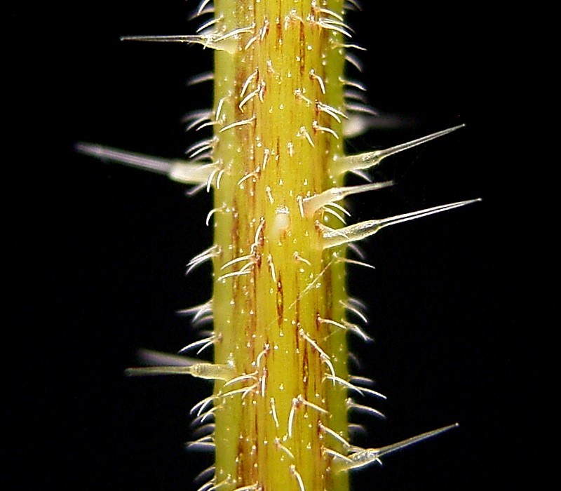 |
| Close up of the Stinging Nettle's stem from Wikipedia. |
At one point it occurred to me that I couldn’t keep a very close watch on the trail route from the creek bed. The map showed the trail heading up the mountain to the left from the creek, at a sharp angle, like 8 o’clock on a clock face, if you are marching toward the twelve. As I climbed out, I didn’t see anything that looked like either a trail or a roadbed with the carpet of nettles (they were, I assure you, all over nonetheless) and retraced my steps in the nettles. I hadn’t gotten too far when I saw a bright yellow diamond on a tree ahead. Every bit of travel was difficult and painful, so I looked from a distance around that tree, did not see a trail heading up the mountain, and decided there must be a trail continuing in these weeds somewhere.
 |
| A sea of stingers. This IS the trail. |
I returned to the creek bed and checked my elevation on the GPS. It wasn’t any help, first because it had turned off (I later determined that it was off for 34 minutes, and I managed to traverse approximately 0.4 miles during this time, which should give you an idea of what I was slogging through), and because it said I already was at 2500 feet, which was the elevation of the road according to the map. Eventually I noticed that the slopes heading up from the creekbed were not as steep as they had been previously, and the nettles did not climb the mountain – they stayed near the creek where there was abundant water. So at 2:45 I decided to go offtrail and head up the mountain heading west. I could come upon the path that goes up the mountain, and failing that could continue to climb until I reached the road. Since the road (FS 396) dead ended heading south part way past the trail, I was taking a real chance here that I had hiked sufficiently north on the trail that I could meet up with the road by heading west. I did not want to think about the consequences if I hadn’t hiked far enough north, however I never felt lost on this hike, even when offtrail. I could always go back the way I had come, but I didn't want to expend the time or effort.
We headed uphill and after only six minutes came to a trail. What a feeling! It headed southwest in the same direction as the trail exiting the river, so we followed it southwest towards the road, even though this took us away from the area we eventually wanted to reach. Combined with the fact that there was an occasional yellow diamond, I was confident I’d made the right choice and I would soon meet up with the road that would cut back north to an intersection with the Shenandoah Mountain Trail. After about 15 minutes, however, the trail cut back east, dropped precipitously, and the GPS showed me going in a circle back down to the streambed! It became clear that I had found the road and taken it back south, rather than finding the trail on its way to meet up with the road. Looking again at the map, there is a section of the road that exactly parallels the trail, and I must have reached the road at that point.
I turned around, took the road(trail) and 39 minutes after first finding the trail hiked past where we had originally picked it up. Heading north, the road/trail edged closer and closer to the stream (at this point not marked on the map as a stream at all) until I was back in a sea of stinging nettles once again. At least it didn’t last too long this time. Looking at the map again today, it is clear that the streambed eventually merged into the road so I should have just followed it as far as possible. But I was too tired and frazzled to look at the map closely enough to determine that at the time.
Tired and in wet boots, I made my way back to the Shaws Fork Trail where I tried unsuccessfully to call home at 4:15 PM, almost exactly 5 ½ hours after last passing the same intersection. We made it back down without incident except for the dog running off at one point after some critter (showing more energy now than at the beginning of the hike and causing me to add to my mental list of additional ways the hike could suck even worse than it did so far: 1. Lightning strike; 2. Lost keys to the car or the car was gone when I returned; 3. Lose my iPhone from its clip on my pack’s belt; 4. Dog runs off in the woods and I have to somehow find her). It took us 90 minutes to return from the SMT.
 |
The Shaw's Fork Trail is a very pleasant hike.
Especially after the BRT! |
I ended up hiking just over 20 miles in 9+ hours. It is officially the longest hike I have ever taken. Total elevation gain: 4347 feet. I should note that I was not wearing shorts on this hike. Instead I had very
lightweight long pants and a
long sleeve shirt treated in an insect guard. I almost never hike in shorts anymore, to guard against ticks and chiggers.
That night I Googled the BRT to see if anybody else had the experience. This trail is slated to become part of the Great Eastern Trail, as it provides one of the few reliable water sources along the SMT. (See this photo:
http://www.greateasterntrail.net/photo_album/get_photo/Pages/12.html) If so, I’m betting nobody has tried it during the summer.
 |
| This map at the traihead promotes the BRT as a legitimate trail. |
On the next day I had amazingly little in the way or residual pain, other than a slight headache that I attribute to dehydration, a blister on one foot, and tight calf muscles. The dog has not moved except to eat and spent our dinner under the dining room table wimpering last night.
 |
| Elevation Profile |
So why haven't I named this trail? I don't want Google searching it. I spoke with someone from the group called the Friends of Shenandoah Mountain, and she told me that mountain bike groups claim the BRT to be a great resource for them, and a reason this area should never get designated a National Wilderness Area (bikes are not allowed in federally designated wilderness areas). Clearly, mountain bikers aren't using or maintaining the trail, and I don't want to give them information that assists them - let them figure it out like I did!
Hike Details
PATC Difficulty Factor 425.2 (a new record)
Total Altitude Gain 4347
Total Distance 20.8 (a new record)
Lowest point 2036 feet above sea level
Highest Point 3844 feet above sea level
Time 9 hours, 14 minutes


