Thursday, December 12, 2013

My GPS Manifesto

There is nothing that can bring out passionate hikers than the question, "do you use a GPS?"  Predictably, there is a tsunami of responses that accuse GPS users of being clueless about their location in the woods and unable to use a map and compass.  And it makes some GPS users defensive, like this blogger.

I think the haters are ignorant.

Let's get one thing straight: nobody loves maps more than I do.  I have been collecting them since at least the third grade, and by age 10 could spout for a half hour about which gasoline companies produced the best road maps.  (I am pretty sure that I am solely responsible for gas stations charging for maps - I would always clean them out when on family road trips.)  I have several maps on the wall in my office, ranging from a relatively new map of the entire Appalachian Trail to an 1855 map of the United States that measures 4 feet by 5 feet.  I treasure the framed 1842 map of the United States over the piano at home.  I am a volunteer for the local trail club's Map Committee.  And I teach map and compass to the Boy Scouts.  In short, I can map and compass circles around most hikers out there.

And I love my handheld GPS.

I never go on a hike without my GPS.  I also take a map and compass.  I use both.  But those who accuse GPS users of having suspect skills are plain wrong.  Both tools have their place.  I don't bring a GPS to help me in case I get lost - a good use of the maps will keep me from getting there.  But there are times when I need an assist and the GPS has helped.  An example is coming down Mt. Lafayette in New Hampshire on the A.T. last summer.  Mt. Lafayette is the tallest mountain in the state not found in the Presidential Range. The top of the mountain is a boulder field.  It is a little harder to find your way there than it is when following a dirt path through a grass covered southern bald.  When I got off course there, my GPS told me to head to the right 20 feet to get back on the trail.  No amount of map and compass expertise is going to tell you that.
Backpacking in the White Mountains,
with my trusty GPS clipped to my belt.
So what is it that gets some hikers riled up about GPS use?  I think there are several things, ranging from elitism to a concern that some hikers out there are not prepared to explore the wilderness.  But I also think a lot of them equate a handheld GPS with the units people have in their cars.  (Which, by the way, I do not have in any of the family cars.)  Listen folks, a handheld does NOT tell you to turn right in 300 steps!

So what is the point of the GPS?  I keep a library of my data.  That way, if I return to a trail I can have a record of how long it took to complete the hike the last time I hiked it.  And I have a record of how long a drive takes to the trailhead.  And I have a record for the IRS in case they ever question the volunteer miles I have driven.  And I can analyze data to get a sense of whether one hike is harder than another.

I have not been blogging much this year, even though I am on pace to set an annual record for most miles hiked.  Much of my time has been spent measuring trails for the Potomac Appalachian Trail Club, using my GPS to increase the accuracy of their maps. The group that is currently obtaining GPS data for each trail in the club's 19 maps.  This has gotten me back on several trails I hadn't hiked in two decades, and added considerably to my own library of GPS trail data.

Several of my colleagues have purchased new Garmin GPS units recently, and I have given them some advice.  It has me thinking that I should go live with a GPS blog - there aren't that many out there, and a new GPS requires a learning curve.  So I am putting out information on that blog specific to learning a new GPS. Check it out!  LINK.

Tuesday, December 10, 2013

Appalachian Trail through Mountain Lake Wilderness

Near Roanoke, the A.T. leaves the Blue Ridge and enters an area of Virginia known as the Valley and Ridge region.  This area is characterized by long folds in the land, creating mountains that look more like large, dead snakes than sharp peaks.  Hiking this region consists of relatively short, steep inclines, long periods with little elevation gain, and steep descents, before crossing a stream valley and doing it all over again.

The Roanoke Appalachian Trail Club led a hike on the first Tuesday in December of one of the sections of A.T. they maintain.  The club has divided up the 120 miles of A.T. they maintain into 14 different sections, and I have done the first eight.  Because it is such a long trip from Charlottesville, I convinced them to allow me to drop my car further up the trail so I could combine their Hike #9 and their Hike #10.  If you are a RATC member and hike all 14 sections, you can earn a patch for your backpack, which I believe shows a blind man about to fall to his death off of McAfee Knob!

After an 8AM meetup with the group at their usual carpool spot - a place called the Orange Market near Roanoke, I dropped my car just of of Virginia Route 42 in a parking lot on a back road.  From there, I joined a carpool to the trailhead, on Route 635 near the town of Interior, Virginia. (Map and directions from Charlottesville: Link) This is really, really remote area!

This is a solid bridge!
We started at 9:48 AM near the edge of the Peters Mountain Wilderness at a parking lot with a large kiosk featuring a map of the area.  We were on the A.T. after a 100 yard journey on a side trail, and wound somewhat mysteriously over hills and streams, only to cross a large bridge over Big Stony Creek and then the same road we came in after 2 miles, and 40 minutes, of hiking.  I can only think that the road itself used to be designated the A.T., and a large amount of work was needed to get it off the road and hugging some steep slopes.

By the time we crossed our road, one other hiker and I had left the 3 others in our group, but my colleague lost steam heading up our first mountain, called "Big Mountain."  After heading back down the slope to check on him, then waiting for him for several minutes at the Bailey Gap Shelter at the 3.6 mile mark, I moved on, knowing that there were members of our group on either side of him.  I knew that daylight was precious, and I would never make the required distance before it got dark if I waited too long.

Bailey's Gap Shelter
The A.T. never seemed to find the top of Big Mountain, preferring to travel along the mountain a couple hundred feet below the ridge line.  It appears from maps that the A.T. once topped the mountain, but it used a woods road, and likely the trail is now off of the ridge to avoid that road.  This section was pretty rocky, so the going was relatively slow.  After 7.2 miles, I entered into the Mountain Lake Wilderness and quickly came across a couple of large outcroppings with wonderful western views.  At one of these outcroppings, called Wind Rock, was the rest of the group, heading southbound on the trail to swap keys with the northbound group.  They were having lunch, and I stopped to check in (briefly) and let them know that the other hiker would have to take the shuttle car, rather than my vehicle.

The Warspur Shelter looks a lot
like the Bailey's Gap Shelter.
Unfortunately, after leaving Wind Rock, I followed the Potts Mountain Trail rather than the A.T.  Figuring that blazing was at a minimum in the wilderness area, I realized my mistake when I pulled out a map to confirm. Fortunately, the A.T. parallels the PMT only a few hundred yards downhill, so I was quickly on the correct trail. Once headed in the right direction, there were few rocks and the trail flew by.  I stopped only to drink water out of streams via my Sawyer Mini Filter - I forgot a water bottle and didn't have time to buy one at the Orange Market. The filter required me to suck directly from the stream, so I had to stop progress to hydrate.  The Sawyer Filter worked great - it is really an incredible instrument, adding only a couple of ounces to my pack's weight.

I stopped a couple of times for water near the Warspur Shelter.  (Really, I just like writing that. What a great name!)  Then I flew downhill past a parking area where my fellow hikers would end their hike, and started back up the A.T., hiking past Rocky Gap to the summit of Johns Creek Mountain Trail.  This was a really tough climb! It averaged at about 20%, and was 15 miles into my journey, so I didn't have a lot of extra gas on this ascent.  

The trail signs in here were really old.  Several had mileage for the a former Big Pond Shelter painted over, and when I later researched this shelter, I discovered that the Big Pond Shelter was moved to the present location of the Laurel Creek Shelter way back in 1988! So these signs are clearly over 25 years old, and they definitely look it.  I thought the first one I came across was bad, but the sign at the junction with the Johns Creek Mountain Trail is nearly unreadable!
At what point is a trail sign beyond its useful life?


Once at the top of John's Creek Mountain, 16 miles into my hike, I knew I had passed the last tough mile.  It was level for another 1.5 miles, then steeply downhill with only a few uphill portions, almost all the way to State Route 42.

The last mile of this was through rolling fields in increasing darkness.  And, just before 42, was a flowing stream in the grass, ankle deep, that successfully soaked both of my feet.  No time to go barefoot!

I crossed 42 and then cruised the last 3/4 mile through fields, allowing me to see the trail despite increasing darkness.  When I reached a stone covered trail in a forested section, it was time to fish around in my backpack for a headlamp.

It turns out, I spent more time finding the headlamp than using it, as I was only 100 yards from the road where I was parked.

I would not rate this as an exciting hike, but I was moving so fast that I failed to stop at either of the major overlooks - Wind Rock and Kelly Knob.  I might feel differently if I broke this hike into two parts.

The longest part of the trail seemed to me to be the section between the Laurel Creek Shelter and Rt. 42.  I was concerned about light, and it was near the end of the hike, which no doubt contributed.

The hardest part of the hike was heading up John's Creek Mountain after crossing a dirt FS Road (Va 601) at Rocky Gap on an old dirt road that goes straight up John's Creek Mountain - a 20% grade over 15 miles into my hike.

Below are the numbers for the entire hike, first with a GPS screen shot taken at the end of my hike. Interestingly, the computer program (shown below that) generates slightly different numbers, and I am not sure the cause of the discrepancy.

.Inline image 1

My GPS Data:
PATC Difficulty Factor497.0
Total Altitude Gain5626feet 
Total Distance21.96miles
Low Point2153feet above sea level
High Point4183feet above sea level
Time of Hike7:55hours: minutes

Be sure to check out other posts at Wandering Virginia.

Friday, October 11, 2013

A.T. Near Roanoke: Lee Hollow (Rt. 621) to Trout Creek (Rt. 620)


Here is another set of photos from an A.T. hike I took back in the Spring with the Roanoke Appalachian Trail Club in Craig County.  This section of trail passes by the Audie Murphy Memorial, close to where the pilot crashed into the mountain back in 1971.  A good read on the monument and the trail is found here: Link.

The hike started on Virginia Route 621, where there is parking for about 12 cars.  It ended also on Rt. 621, where it meets Rt. 620.  We parked here because of a stream crossing on 620 - the trail leader did not trust the privately owned bridge over the stream to hold a car!  The hike was 9.3 miles long, was hiked in just under 3 hours 50 minutes, plus about a half hour stopped.  Minimum elevation: 1488 feet.  Maximum elevation: 3120 feet.

The hike, heading northbound on the A.T. starts by traversing the Brush Mountain East Wilderness, a new (2009) wilderness on the north side of Brush Mountain.


Thursday, October 10, 2013

A.T. Near Roanoke: Sinking Creek to Lee Hollow


Here is a set of photos from another section of the A.T. near Blacksburg.  This is the southernmost portion of a continuous section of the A.T. I have hiked into Maryland.

This section's highlight landmark is the 300 year old Keffer Oak, shown below in the 2nd photo.  Some say it is the largest oak on the entire A.T.  Others say one in New York is larger.  Still others say they are each about equal.

The hike started on Virginia Route 630, where there is parking for about 6 cars.  It ended at a larger parking lot on Virginia Route 621.  The hike was 10.4 miles long, was hiked in just under 4.5 hours, plus about an hour stopped.  Minimum elevation: 1535 feet.  Maximum elevation: 3522 feet.


Wednesday, October 9, 2013

Rivanna Redux

I accompanied my Boy Scout Troop on its annual 20 mile hike around Charlottesville this past weekend.  (I say "my troop" because I was recently named Scoutmaster.)  We had 6 boys complete the entire 20 miles, and one boy join after 7 miles, a second join after 8.5 miles and a third join after 10 miles.  

The troop did a similar Rivanna loop almost exactly a year earlier, described here: Link.  This year we did it counter-clockwise, while in 2012 we did it clockwise.


Why do the Rivanna Trail?  It really isn't very interesting compared with a lot of trails within an hour of Charlottesville.  But there are several reasons.  Number one: it is open!  Shenandoah National Park is currently closed.  But more important, it is pretty flat, which is good when boys need to get 20 miles for their Hiking Merit Badge.  And the badge requirements don't differentiate between flat land and mountainous trail when it says "20 miles."  Another great thing is that is near where all the scouts live, and the group is always accessible by cell phone.  So we had the option of getting a hurt hiker picked up (which didn't happen this year), adding boys along the way who had sports or work commitments that morning, and setting up refreshment stations along the way. (Thank you Ms. Troyer!)

This year, we even had a couple of mock first aid incidents along the way, set up by one of the parents who is a nurse.  (Thank you Ms. Vincel!)

I still remember my 20 miles as a boy, fulfilling my Hiking Merit Badge requirement.  It was on the Blackhawk Trail, along the Rock River in Illinois.  There were two high points - at the Blackhawk statue overlooking the Rock River, and at another spot called "Whirlpool Rock."  I am glad to see the trail still exists.  I hope one of these boys has similar feelings about the Rivanna hike when he is an adult.

I don't recall seeing another hiker (other than folks walking and biking the Riverside Trail portion), but we did see three mountain bikers.  There was a tent just off the trail near the 5th Street Holiday Inn (homeless perhaps?)

Our route was slightly different than last year, as can be seen by the map below.  2012 is in purple, and 2013 is in blue.  On the south end, we took trails around the Willoughby subdivision - public, but not actually part of the Rivanna Trails system (thanks to a parent familiar with these trails).  I had never done this part of the hike before, so it was my favorite.

Also unlike in 2012, we didn't follow the trail to its dead end north near Greenbrier Elementary School because we knew we would get close to 20 miles without adding that street/trail combination.  And we didn't take the trail between Emmet Street and Barracks Road because we couldn't cross Emmet safely - UVA football traffic was heading back north, and the crosswalk signal was not working.  

Overall, however, the trips compare remarkably well.  Comparing numbers from each year:

2013: 19.8 miles, Moving time: 7:30; Stopped time 2:03; Moving average: 2.6 mph
2012: 20.4 miles, Moving time: 7:31; Stopped time 2:09; Moving average: 2.7 mph

It is interesting to see that moving and stopped times are virtually identical.  We moved faster in 2012, which accounts for the additional half mile hiked in 2012 over the same time length.  There is a Scout saying that "you only travel as fast as your slowest hiker."  Our hikers were generally the same as in 2012, so I expected a slightly faster pace.  One of the other leaders claims we had a faster pace setter for the last part of the 2012 hike, which would explain our slower pace this year.

The ugliest part of the hike is the street walk at about 4:00 on the clockface above.  Today, the local news reports police are investigating a possible Meth Lab on a street we walked on Saturday.  I am glad they weren't investigating that on Saturday when we were walking by!  

Wednesday, September 25, 2013

The Hardest Dayhike in Virginia

A while back Backpacker Magazine published an article on "America's Hardest Dayhikes."  Link.  It is important to note that the article was written by Backpacker's "Northwest Editor," which begs the question, "what does he know about eastern hikes?"

Nevertheless, it is an interesting list, despite being ridiculous in many ways.  How, for example, can a 41 mile hike be called a "dayhike"?  He gives top honors to a hike in his region (naturally) that is that long, even though his #2 gains half again as many feet in elevation over nine fewer miles.  And, having done a part of the #2 hike (New Hampshire's "Pemi Loop" over Mt. Garfield, Mt. Lafayette, and South Twin Mountain) over two days, I can personally vouch for the extreme difficulty of this hike.  At one point, I swear I was hiking down an actual waterfall.  Check out the elevation changes and steepness of this trail, below.


No Virginia hike is listed.  Is there a Virginia hike that matches any of the 10 hikes listed?  If not, what is the hardest day hike in the state?  My vote would go to the Wild Oak Trail west of Staunton, as it comes close in numbers to the listed trails, at gains just a foot under 8700 feet elevation over 27.4 miles.  I have done it as a dayhike each of the past two Springs (once in each direction), and each time I swear never to do something that stupid again!  Link.  You simply cannot avoid steep ascents in either direction around the 15 mile mark, and it leaves you worn out for the rest of the hike.

Tuesday, September 10, 2013

Whetstone Ridge Trail, September 9, 2013

"Time is the biggest enemy of all maps." - Bob Warring, Assistant Scoutmaster, Troop 1028, Professional Forester.

The Whetstone Ridge Trail starts on the Blue Ridge Parkway, not far from where Virginia State Route 56 crosses the parkway on its way to Spy Rock and Crabtree Falls. Allen DeHart's book, The Trails of Virginia, states that this is the longest trail in the Pedlar District of George Washington National Forest. Because it is over 10 miles long, an out and back hike has never seemed feasible, so I always kept an eye out for Potomac Appalachian Trail Club hikes heading out to that trail.

Instead, I ended up signing up for a scheduled hike with the Roanoke Appalachian Trail Club when they listed it.  I joined the RATC at the beginning of the year and have hiked often with them this year as I extended my continuous mileage on the A.T. in Virginia from around 200 miles at the beginning of this year to about 350 miles now.  The Whetstone Ridge Trail is the northernmost hike I have done with them, and it didn't make sense to drive south to Roanoke then back north to the trailhead.  So I arranged to meet the group at the southern end of the trail, where our hike would end.

The RATC folks met up in Roanoke at 8AM and said they would be on the trail by 9, so I figured that must mean they would be near the end of the hike by 8:30.  I left home at 7:15 and was at the trailhead by 8:20.  I made sure I knew exactly where the trailhead was as I'd never been on the road before.  I entered waypoints in my GPS telling me where to go, from Exit 200 on Interstate 81, to U.S. 11, to Red Hill Road, to South River Road, to Irish Creek Road, to the trailhead parking lot.  No problems getting there.

I had extra time, so I looked around a little.  Although there was no trailhead sign, the parking area was large, there was a clear trail heading uphill across the road, and that trail was marked by a large plastic yellow diamond on one of the trees.  So I waited.  And waited.

Finally about 45 minutes later a pickup closely followed by a car drove by.  It was the first caravan the entire time.  The pickup had an AT sticker.  It must be them, and they must have missed the turnoff.  They will be right back.  But nobody showed, and I was deep into the map determining a Plan B hike when the pickup came back my way.  It was Dan, the group leader, saying that the trailhead had moved and I was in the wrong spot.  Yeah, despite the yellow diamond on the tree.

We were fortunate that Dan had scouted the trail when he stepped forward to lead the hike, as he was right about the trailhead. I followed him 2.5 miles up Irish Creek Road, to a much smaller parking lot that had a brown hiker sign and a trail into the trees.
The trail's first few miles are on (or closely parallel) an old road,
and are wide and flat.

I joined a couple of other folks in the back of a covered pickup and 20 nausea-induced minutes later, seven of us found ourselves at the Whetstone Ridge Visitor's Center on the Blue Ridge Parkway.  Big parking lot. Flush toilets (in season).  We were on the trail by 10, heading north by northeast.  Not exactly the direction I expected, since we had come up from the southwest!  But we soon took a sharp left and walked along a ridge for several miles.

If you keep looking down, there's no doubt you are on the trail,
despite the overgrowth.
The trail generally followed an old road, though it often broke away to parallel the road - sometimes only for a couple hundred yards before rejoining the road.  Since the trails were clearly not built to stem erosion on the road (it was not rutted), I concluded that they were built by mountain bikers to provide a level of adventure an old woods road cannot give.   Eventually the road faded away and we were on a rocky trail on the crest of Whetstone Ridge, with very little elevation change between miles 2 and 4.  After mile 4, we dropped off the ridge and moved over to South Mountain, which was really a series of steep ups and downs, with a few nice views thrown in.  There were six of these mini peaks in all, with some steeper and longer than others.  We nearly skated down one slope in loose debris, dirt and rocks.  And by this time, the trail was often very overgrown.
Looking southeast from Whetstone Ridge, towards the Blue Ridge Parkway, and beyond, the A.T. near the
Seely-Woodworth Shelter.
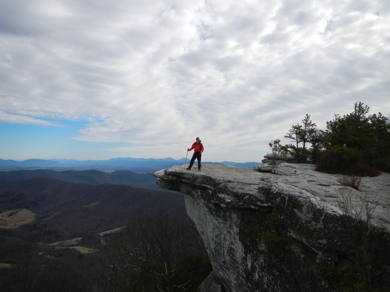
The trail goes near Adams Peak, with limestone rocks jutting out of its northern face.  Adams Peak provides a good goal for a return trip - it looks like views from the top of that peak would be spectacular.  And it would not be a tough bushwack from the trail, which rides a ridge very close to the peak.
Adams Peak visible through the trees.
The trail also passed right next to a wildlife blind before coming to a sign telling us to take a sharp left to start down the slope.  This is where the new trail alignment left the trail found on all my maps.  Other than the sign, though, there was no barrier to indicate that the old trail has been superseded, and a downed tree had been freshly cut.  I think the old trail is still used, probably also by mountain bikers.  So I am going to guess the new trail was built by the same group.  It had a very steady descent, and is probably a much easier ride than the older trail.  The new trail was actually very pretty, descending next to a couple of stream cuts in the mountain.  Parts of the new trail had stone walls built up the slope to keep the trail at an even grade - very nicely done.
Group shot from one of the few overlooks on the trail.  Thanks to Hike Leader Dan for taking this photo!
A new mileage sign at the southern end of the trail.
Elevation Profile, Whetstone Ridge Trail
Overall, I found this to be a tough trail, and I remain sore two days later.  Hiking it in the opposite direction would be really tough!  (Though it would provide a way to do this hike solo - if you hide a bike near the Whetstone Ridge Visitor's Center and start the hike from the south - you can roll back down to your car.)  We ran into one other hiker - a guy with an old external frame backpack who said he was tenting along the trail and out giving his Garmin GPSMap 62s its initial workout.  I showed him that I had the same model and advised him to stick with it - understanding its capabilities takes time!  I don't think the trail sees a lot of use, except maybe by mountain bikers and hunters in season.  Fortunately, the slopes appear to stay pretty dry. There are no road crossings or exit points on the trail, so if you are on your own you better not get hurt. Much of the trail goes through an area the US Forest Service calls the "Mt. Adams Roadless Area."  This is some pretty remote forest - among the more remote areas east of Interstate 81.

Coordinates for the southern trailhead: Irish Creek Road.  N37 49.152 W79 15.237  (Directions and Map from Charlottesville: Link..)
Coordinates for the northern trailhead: Blue Ridge Parkway Milepost 29, Whetstone Ridge Visitor's Center.  N37 52.176 W79 08.873  (Directions and Map from Charlottesville: Link.)

My GPS Data:
PATC Difficulty Factor264.4
Total Altitude Gain2855feet
Total Distance12.25miles
Low Point1435feet above sea level
High Point3167feet above sea level
Time of Hike5:34hours: minutes

Sunday, July 21, 2013

A.T. Near Roanoke: Catawba Mountain ( Rt. 311 ) to Dragon's Tooth Parking Lot

On February 21st I joined the Roanoke Appalachian Trail Club for its third Tuesday hike of the Appalachian Trail.  I don't recall now why we moved it to Thursday; probably due to weather.  This day was a spectacular one as you can see from the photos, with incredible blue skies.  In Virginia, there are few months better for hiking than a crisp February day.  On the other hand, it is impossible to determine what day that might be more than a few days in advance.
Sawtooth Ridge from further south on the A.T.
The past couple of weeks the group had done two sections of the Appalachian Trail near Roanoke.  On this day we headed further south on the trail, heading towards, but not reaching, the rock monolith known as Dragon's Tooth.

We started at the same starting point for the previous week's hike over McAfee Knob - State Route 311, about 10 minutes west of Interstate 81.  We headed over an area called Sawtooth Ridge (a part of Catawba Mountain), but I found the area wasn't as tough as it looked from the road.  The trail doesn't go over each peak in the sawtooth, but skirts around a lot of them.  The ridge lasted for 3 miles, and took us a little under an hour and a half as a group.  

When we reached Beckner Gap, the trail dropped off of Catawba Mountain and into a valley where we crossed several styles designed to keep animals from roaming, and various tributaries of Catawba Creek.

We eventually climbed back up to obtain spectacular views from Viewpoint Rock, climbing along a thin rock ridge.
The view from Viewpoint Rock


A short distance after Viewpoint Rock we reached Lost Spectacles Gap, so named because a Roanoke club volunteer lost his glasses here.  We took the blue blazed trail back 1.5 miles to our vehicles in the large Dragon's Tooth parking lot.  

A Short A.T. Hike, Just North of the James River

The view from the Purgatory Mountain Overlook on the BRP.
On Monday, July 15th I was up at 4 A.M. to drop my son and his Scoutmaster off at the Waynesboro Home Depot so they could take a charter bus to the Boy Scout National Jamboree in West Virginia.  It was a beautiful morning and, even though it promised to be hot later, I could not pass up the opportunity to head out to the Blue Ridge Parkway and finish up several very small sections of the Appalachian Trail that I had not completed.  (One of the three was not more than 100 yards, but I want to be complete in my completions!)


The first two sections were nothing to write about, as they were within sight of the Blue Ridge Parkway and really not very interesting.  (The view from the BRP itself, though, was spectacular!  At least until the heat burned off the low level clouds.)  I was expecting to be similarly underwhelmed with the day's third section, but was very pleasantly surprised.

The view from the Foot Bridge of a rain-swollen James River.
The section of the Appalachian Trail just north of the James River is relatively new.  Back in 2000, the A.T. moved its James River crossing from a somewhat nerve-wracking route along the side of the U.S. 501 bridge to a special pedestrian bridge specifically for the Appalachian Trail.  Named the "James River Foot Bridge" after thru-hiker Bill Foot, who negotiated rights over a long period of time.  It was constructed on piers from an 1881 railroad bridge. The bridge and its parking lot have proven very popular with locals - so popular that the U.S. Forest Service, which oversees the bridge, has had to implement restrictions on partying and swimming in the area.  Link.

When the Foot Bridge was opened, the A.T. was rerouted to meet U.S. 501 at the bridge.  Because much of my A.T. hiking in this area dates to before the bridge was completed, I needed to come back here and hike the reroute so I could say I had hiked a continuous section of the A.T.  This was my last section, completing a continuous section of about 250 miles.

As I stated, I expected to be underwhelmed, because this section was designed to link two existing parts of the trail.  But I could not have been more wrong.  This is one of the more delightful sections of trail that I have seen in Virginia.

First bridge, looking from the northern end of the trail.
The trail starts by crossing Rocky Row Creek on a nicely constructed wood bridge.  It then hugs the side of a slope, held there by expert construction of log barriers.  Because of the steepness of the ravine, the noise of U.S. 501 becomes nearly imperceptible almost immediately.    The trail then crosses the stream again, and climbs the ravine on a series of steps that show great craftsmanship in their construction.
Another shot of the first bridge.
The trail drops quickly to the second bridge.
Check out the construction of these steps.
 After a little over a mile, the trail climbs out of the ravine to cross the Hercules Road.  It was at this point that I turned around, as I had previously completed the A.T. north of this road.  The Trail here heads north past the Johns Hollow Shelter (where I spent part of a migraine-shortened November night back around 1994), and up to spectacular views from Fullers Rocks.

According to the current Appalachian Trail Guide for Central Virginia, the trail that parallels the creek "was part of the original 1930 A.T. [alignment]."  The bridges were built in 1999 by the Forest Service, Konnarock Trail Crew (an A.T. trail crew that takes on big projects throughout Virginia), and volunteers from the Natural Bridge Appalachian Trail Club.  It was a job well done.

Thursday, April 25, 2013

A.T. Near Roanoke: McAfee Knob and Tinker Cliffs

Week 2 of my tour of the Roanoke Appalachian Trail Club's section of the Appalachian Trail started near (guess where?) Roanoke.  I had the pleasure of again hiking with Ed and Mike, both of whom I had met the week before on my first RATC hike, and we added John to this hike.
Climbing from the parking lot on Rt. 311

It is hard to imagine another section of trail that the RATC covers that could be more spectacular than this hike.  In fact, I haven't found any section of trail anywhere in Virginia more scenic than this one. While everyone seems to say that Mt. Rogers is the best hiking in Virginia, I think McAfee's Knob and Tinker's Cliffs are the best.  In fact, Virginia has a rendering of McAfee Knob on its A.T. license plate.

It is said that McAfee Knob is the single most photographed spot  on the A.T., and I can see why. It is really a breathtaking spot.

This is also a very popular hike, and, though we didn't see many folks on the day we hiked, the wear on the trail was evident.  A Tuesday in mid-February is a good time to see the sights without encountering many folks.

We left the large parking lot on Route 311 at 9:12 AM, and 27 minutes later passed the first of three A.T. shelters we would see on this short section of trail, the John's Spring Shelter.  Mike told me about the RATC's problem a couple of years back with a young fellow from Lexington who liked this area so much he basically moved in on weekends and kept his tent up when he was back home.  They had to drag his tent and all of his stuff back to the parking lot, including quite a bit of electronics.
Normal clouds look spectacular here.
The ridge to the left of the rock was our route towards Tinker Cliffs.

At McAfee, with North Mountain in the background.
An hour into the hike we were at the Catawba Shelter, which also has a nice campsite nearby.  From Catawba it is a 2 mile hike to McAfee, and a 1000 foot elevation gain, which calculates out to about a 9% climb.  And 50 minutes later we were at the edge of McAfee Knob.  You can't just pass by, so we stopped, snacked, and snapped a few photos.  And I can confidently say that at 11 AM on February 12th, 2013, I was photographed for a shot that I will hold on to for the rest of my life.  And I will always state, "photos do not do justice to this view."

We projected to have a long hike, so we only stayed here for 10 minutes.  And my colleagues told me that the view from Tinker Cliffs is actually better!  So I was anxious to see what was next.

We took a short detour through a spot with large rocks called Devil's Kitchen before dropping to the Campbell Shelter at just under 5 miles.  We snacked briefly here, and snacked again at a rocky spot with a nice view to the east at the 7.25 mile mark.  At 8 miles we dipped to meet the Brickley Gap Trail, which bypasses Tinker Cliffs in favor of a straight shot to the Lambert's Meadow Shelter with little of the elevation gain climbing to Tinker.
But we had purchased the ticket for the full ride on this hike, and climbed about 850 feet over the next mile-and-a-half to the Cliffs.  And the view from the cliffs is at least the equal of the view from McAfee Knob.  Better, I think, because you get a longer view down the valley.
The trail sometimes hugs the edge of the cliffs.

Another tourist photo!

Hiking along the cliffs' edge.

The view southeast from Tinker Cliffs.
McAfee Knob is the highest point on the left side of the photo.
From the cliffs it was a little under a mile to the Andy Layne Trail and another 2.9 miles to the car, parked at the trailhead parking lot on Route 779.  The end result was a hike only about 350 feet longer than the hike the week before, which is pretty amazing over such a long hike.  The bigger difference is the additional 750 foot elevation gain in this hike.

Bottom line: This is quite a hike!  Highly recommended.


Hike Details.
PATC Difficulty Factor 323.9
Distance:  13.4 miles
Total Time: 6 hours 40 minutes.
Lowest point: 1333 ft.
Highest point: 3225 ft.
Total uphill: 3929 ft.