Near Roanoke, the A.T. leaves the Blue Ridge and enters an area of Virginia known as the Valley and Ridge region. This area is characterized by long folds in the land, creating mountains that look more like large, dead snakes than sharp peaks. Hiking this region consists of relatively short, steep inclines, long periods with little elevation gain, and steep descents, before crossing a stream valley and doing it all over again.
The
Roanoke Appalachian Trail Club led a hike on the first Tuesday in December of one of the sections of A.T. they maintain. The club has divided up the 120 miles of A.T. they maintain into 14 different sections, and I have done the first eight. Because it is such a long trip from Charlottesville, I convinced them to allow me to drop my car further up the trail so I could combine their
Hike #9 and their
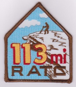
Hike #10. If you are a RATC member and hike all 14 sections, you can earn a patch for your backpack, which I believe shows a blind man about to fall to his death off of McAfee Knob!
After an 8AM meetup with the group at their usual carpool spot - a place called the Orange Market near Roanoke, I dropped my car just of of Virginia Route 42 in a parking lot on a back road. From there, I joined a carpool to the trailhead, on Route 635 near the town of Interior, Virginia. (Map and directions from Charlottesville:
Link) This is really, really remote area!
 |
| This is a solid bridge! |
We started at 9:48 AM near the edge of the Peters Mountain Wilderness at a parking lot with a large kiosk featuring a map of the area. We were on the A.T. after a 100 yard journey on a side trail, and wound somewhat mysteriously over hills and streams, only to cross a large bridge over Big Stony Creek and then the same road we came in after 2 miles, and 40 minutes, of hiking. I can only think that the road itself used to be designated the A.T., and a large amount of work was needed to get it off the road and hugging some steep slopes.
By the time we crossed our road, one other hiker and I had left the 3 others in our group, but my colleague lost steam heading up our first mountain, called "Big Mountain." After heading back down the slope to check on him, then waiting for him for several minutes at the Bailey Gap Shelter at the 3.6 mile mark, I moved on, knowing that there were members of our group on either side of him. I knew that daylight was precious, and I would never make the required distance before it got dark if I waited too long.
 |
| Bailey's Gap Shelter |
The A.T. never seemed to find the top of Big Mountain, preferring to travel along the mountain a couple hundred feet below the ridge line. It appears from maps that the A.T. once topped the mountain, but it used a woods road, and likely the trail is now off of the ridge to avoid that road. This section was pretty rocky, so the going was relatively slow. After 7.2 miles, I entered into the Mountain Lake Wilderness and quickly came across a couple of large outcroppings with wonderful western views. At one of these outcroppings, called Wind Rock, was the rest of the group, heading southbound on the trail to swap keys with the northbound group. They were having lunch, and I stopped to check in (briefly) and let them know that the other hiker would have to take the shuttle car, rather than my vehicle.
 |
The Warspur Shelter looks a lot
like the Bailey's Gap Shelter. |

Unfortunately, after leaving Wind Rock, I followed the Potts Mountain Trail rather than the A.T. Figuring that blazing was at a minimum in the wilderness area, I realized my mistake when I pulled out a map to confirm. Fortunately, the A.T. parallels the PMT only a few hundred yards downhill, so I was quickly on the correct trail. Once headed in the right direction, there were few rocks and the trail flew by. I stopped only to drink water out of streams via my
Sawyer Mini Filter - I forgot a water bottle and didn't have time to buy one at the Orange Market. The filter required me to suck directly from the stream, so I had to stop progress to hydrate. The Sawyer Filter worked great - it is really an incredible instrument, adding only a couple of ounces to my pack's weight.
I stopped a couple of times for water near the Warspur Shelter. (Really, I just like writing that. What a great name!) Then I flew downhill past a parking area where my fellow hikers would end their hike, and started back up the A.T., hiking past Rocky Gap to the summit of Johns Creek Mountain Trail. This was a really tough climb! It averaged at about 20%, and was 15 miles into my journey, so I didn't have a lot of extra gas on this ascent.
The trail signs in here were really old. Several had mileage for the a former Big Pond Shelter painted over, and when I later researched this shelter, I discovered that the Big Pond Shelter was moved to the present location of the Laurel Creek Shelter way back in 1988! So these signs are clearly over 25 years old, and they definitely look it. I thought the first one I came across was bad, but the sign at the junction with the Johns Creek Mountain Trail is nearly unreadable!
 |
At what point is a trail sign beyond its useful life?
|
Once at the top of John's Creek Mountain, 16 miles into my hike, I knew I had passed the last tough mile. It was level for another 1.5 miles, then steeply downhill with only a few uphill portions, almost all the way to State Route 42.
The last mile of this was through rolling fields in increasing darkness. And, just before 42, was a flowing stream in the grass, ankle deep, that successfully soaked both of my feet. No time to go barefoot!
I crossed 42 and then cruised the last 3/4 mile through fields, allowing me to see the trail despite increasing darkness. When I reached a stone covered trail in a forested section, it was time to fish around in my backpack for a headlamp.
It turns out, I spent more time finding the headlamp than using it, as I was only 100 yards from the road where I was parked.
I would not rate this as an exciting hike, but I was moving so fast that I failed to stop at either of the major overlooks - Wind Rock and Kelly Knob. I might feel differently if I broke this hike into two parts.
The longest part of the trail seemed to me to be the section between the Laurel Creek Shelter and Rt. 42. I was concerned about light, and it was near the end of the hike, which no doubt contributed.
The hardest part of the hike was heading up John's Creek Mountain after crossing a dirt FS Road (Va 601) at Rocky Gap on an old dirt road that goes straight up John's Creek Mountain - a 20% grade over 15 miles into my hike.
Below are the numbers for the entire hike, first with a GPS screen shot taken at the end of my hike. Interestingly, the computer program (shown below that) generates slightly different numbers, and I am not sure the cause of the discrepancy.
.

My GPS Data:
| PATC Difficulty Factor | 497.0 | | |
| Total Altitude Gain | 5626 | feet | |
| Total Distance | 21.96 | miles | |
| Low Point | 2153 | feet above sea level |
| High Point | 4183 | feet above sea level |
| Time of Hike | 7:55 | hours: minutes |
