This post details a 7 mile out-and-back hike on the southernmost section of the Shenandoah Mountain Trail in Bath County, Virginia. This is a moderate hike with several short steep climbs and features a wonderful view at its northermmost point. There is much solitude to be found on this trail - you may come across some mountain bikers, but your odds of finding another hiker are nearly nil.
The Shenandoah Mountain Trail is one of the longest and oldest trails in the George Washington National Forest. It stretches over 37 miles riding the ridge of Shenandoah Mountain and dates back over 100 years - it is perhaps the first trail ever built in the Shenandoah National Forest - the precursor to today's George Washington National Forest. Many hikers have experienced the Shenandoah Mountain Trail (SMT) north of U.S. 250, as it heads north from Confederate Breastworks to Ramseys Draft Wilderness. South of U.S. 250, however, relatively few hikers have experienced this trail. It is so long that it is actually best traversed by mountain bike. And heatmaps show that mountain bikes traverse the entire length of the trail, including, illegally, within the boundaries of Ramsey's Draft Wilderness. (Bikers have told me that "It is OK, because the trail is the wilderness boundary, so riding on the western edge of the trail keeps you outside of the boundary." But that is wrong - the boundary extends past the trail and riding bikes within the wilderness violates federal law.)
At its southern end, the SMT is a very remote and wild trail. It requires driving south from West Augusta and US 250 over 20 miles into Bath County. But parts of the drive are spectacularly beautiful, and paved roads extend all the way to the trailhead. It is an especially good Winter hike, because the conditions of the access roads are excellent.
Perhaps the hardest thing about this hike is finding where the trail starts. So I will go into detail on that. Drive south from US 250 at West Augusta through Deerfield. After Deerfield, you will pass through some large farms and into Bath County. There are wonderful views of Walker Mountain to your left and Shenandoah Mountain to your right, with Chestnut Ridge straight ahead.
Take the Deerfield Road all the way south to Rt 678, Indian Draft Road - 22.2 miles from US 250. Take a right on 678. This road is marked by number only, and not by name.
Take Indian Draft Road until you see the Cowpasture River on your left. There is a wide parking area on the side of the road just before the bridge over the Cowpasture River. Park here, making sure to leave nothing of value visible to anyone who might take an interest in an unmanned vehicle. You will start by walking back east on the road for a quarter mile, retracing the last bit of driving you made.
Look for a telephone poll on your right, with a support cable that crosses over the road onto the slope on your left side. On that slope, you will see a Carsonite trail marker (a flat metal post planted in the ground) and several blazes. This signals where the trail starts, and is pretty easy to see when walking along the road from the west. (It is a lot tougher to see when coming from the east.)
This segment is a recent addition to the Forest Service trail inventory. It climbs via a couple of switchbacks to a ridge at the top, where the trail then follows an old woods road. The trail originally continued east on that woods road along the ridge into private property before reaching the main road. This new segment keeps the trail on Forest Service land. (And, not suprisingly, heat map data shows most bikers ignoring this trail and continuing on the ridge to Indian Draft Road. Trespassing? Or does the landowner - the Ft. Lewis Lodge - allow it? I don't know.)
Once it reaches the ridge, the trail heads left, continuing uphill and away from the national forest boundary. There are nice winter views of the Cowpasture River and the
Ft. Lewis Lodge - a spectacular bed and breakfast open April through October.
Near the top of the ridge, the trail curves to the right away from river views and into the mountains. You need to keep an eye out for the curve. A tree is blazed yellow, but it is some distance from the curve in the trail and easy to miss.
From here, you drop away from the occasional road noise of Indian Draft Road and into the National Forest. My hiking companion noted when hiking this portion that the sense of quiet is truly amazing here. You hear nothing except forest sounds - not even any airplanes. For a section of forest so close to paved roads, this is a truly remote area.
The trail heads generally eastward through remote forests along ridges, sometimes with steep dropoffs on either side of the ridge. There are a couple of really steep climbs in this part of the hike, especially at the 1.5 mile mark. Overall however, the trail is relatively well blazed and easy to follow. In winter, there are nice mountain views in the distance.
At the 2.5 mile mark, the trail drops down and crosses Rt 627, Scotchtown Draft Road. This is a dirt forest service road that provides a closer parking option to the overlook that is our destination.
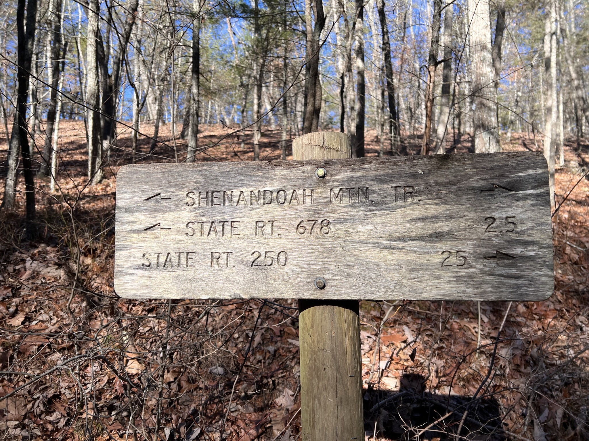
There is also a trail mileage marker here which has a pretty unique feature - one that slams home the remoteness of the Shenandoah Mountain Trail. Check out the sign.
Ignore the fact that it refers to "State Rt. 250" when the highway is actually U.S. 250 - a federal highway. When do you ever come across a trail mileage sign that includes a landmark 25 miles away? I cannot think of another sign with such a distant landmark anywhere in Virginia.
Continue north on the SMT from this road, passing another Carsonine post and a small maker stating that this is part of the
Great Eastern Trail, a new long distance trail that goes from New York to Alabama.
The trail starts ascending with real purpose now. Not as steeply as in earlier portions, but steadily and unrelenting. Notice after about a mile that the forest changes as you cross a section that is on the edge of a shale barren - trees are much less prevelant compared to the rest of the forest after the road crossing. The trail will take a right following the contour of the mountain. Keep an eye out for a metal arrow on a tree to the left of the trail and, at the same point, a side trail heading to the right.
Climb steeply to to the open point on the mountain. Many distant locations can be seen from here, including
Rough Mountain Wilderness and Warm Springs Mountain. If you look carefully, you can see Scotchtown Draft Road, which you crossed on your way here. This is truly one of those "photographs do not do it justice" locations!
Retrace your steps from here back to your vehicle. Note that, on your way back, there is one point where the trail south of Scotchtown Draft Road is difficult to follow when heading south. If you are a ridgetop and suddenly do not see any blazes on the trees, you may have gone straight on a ridge when the trail cut right down off of the ridge. Keep an eye out for blazes!
Data:
Hike distance: 7.3 miles
Total Ascent: 2163 feet
Minimum Elevation: 1703 feet
Maximum Elevation: 2875 feet


.jpeg)

.jpeg)

No comments:
Post a Comment
Note: Only a member of this blog may post a comment.