Just like earlier this year when I ended up hiking the
Chimney Hollow Trail several times in the space of a couple of months, I have been on the Ramsey's Draft Trail three times in the past several weeks. The Ramsey's Draft Trail is the primary trail within
Ramsey's Draft Wilderness, the closest wilderness to the D.C. area and to Charlottesville.
 |
I help clear a section of the Ramsey's Draft Trail.
Expand this photo to see how bad the debris is
behind me on the trail! |
Ramsey's Draft is located about 25 miles west of Staunton, just north of U.S. 250. (
Topo Map.) The area has a wonderfully complex history, both natural and man-made.
The U.S. Forest Service first purchased land in this area in 1913 for Shenandoah National Forest, the precursor to the present day George Washington National Forest. The Forest Service has managed the Ramsey’s Draft area essentially as a wilderness since 1935 as much of it had never been logged. A road more than three miles upstream from U.S. 250 constructed by the Civilian Conservation Corps in the 1930s lasted until 1969, when rainwater from Hurricane Camille wiped out much of the road at the stream crossings. Another flood in November 1985 further eliminated the original road and changed the course of the stream in multiple areas, shortly after the area was officially designated a wilderness under the Virginia Wilderness Act of 1984.
 |
| Hiking that same section, several weeks later. |
I have hiked this wilderness for many years, dating back to when I first moved to Charlottesville twenty years ago. It was a vastly different place back then, as it was famous for its old growth hemlock trees that gave the draft valley a primeval, dark feeling. An evil little bug called the woolly adelgid has killed off many of these magnificent trees, opening up much of the forest floor to sunlight, probably for the first time in hundreds of years. For those of us who remember the way it was, it is still a bittersweet place to visit these days.
 |
Second trip for trail work on the Ramsey's Draft Trail,
this time with Dan and Iva of the Charlottesville
PATC Chapter. |
It also requires a lot of work to keep the trails clear, as dead trees tend to fall down, blocking pathways. My first two (recent) hikes in the wilderness area were with the incredibly dedicated folks in the Southern Shenandoah Chapter of the Potomac Appalachian Trail Club. Whenever I need to know something about the woods west of Staunton, these folks know the answer.
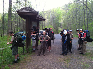 |
Signing in at the trail register at Mountain House trailhead
before a 3 day backpacking trip. |
Case in point: a friend told me he saw miles of string on the Shenandoah Mountain Trail in Ramsey's Draft, and told me one of his group had taken a photo of a bird that had died when it became tangled in the string and placed this photo on Facebook. I emailed one of the SSVC members. Not only did she know about the string, but she told me why it was there, that her group had already picked up miles of the stuff, complained to the Forest Service, and seen the same photo and emailed it as evidence that such string should never be used to determine trail mileage. Wow.
Both work trips concentrated on the Ramsey's Draft Trail, which generally follows the path of the old road mentioned above, and crosses the stream known as Ramsey's Draft multiple times over the first 2.5 miles. These trips went a long way towards making the trip on this trail much easier. So much easier, in fact, that we met a mountain biker illegally using the trail. Mountain bikes are not permitted in wilderness areas, and as a result the local mountain bike community has fought expansion of wilderness in Virginia. This guy, though he claimed to be a Richmond environmental consultant, claimed ignorance of the wilderness boundaries, and even that bikes were prohibited in the wilderness.
The true test of trail conditions, however, was in my third trip up the trail when I led a group of Boy Scouts on a 3 day backpacking trip in the wilderness. We had been working for several weeks on obtaining lightweight backpacking skills, and this would be our test. The boys had come to an earlier meeting with fully loaded packs, which we analyzed for further weight savings. When we collected in Charlottesville to carpool to the trailhead, we weighed packs but did not dump each pack's contents. Given the fact that the boys' packs weighed anywhere from 20 to 40 pounds, we probably should have checked a few loads.
We started out on Friday evening, and hiked as far up the Ramsey's Draft Trail as possible before total darkness forced us into a small campsite next to the stream. I am pretty sure I ended up camping in a bit of poison ivy, but have suffered no effects. There is quite a bit of poison ivy on this trail, which is seeing much more sunlight than it has in many years, thanks to the deaths of the hemlocks.
 |
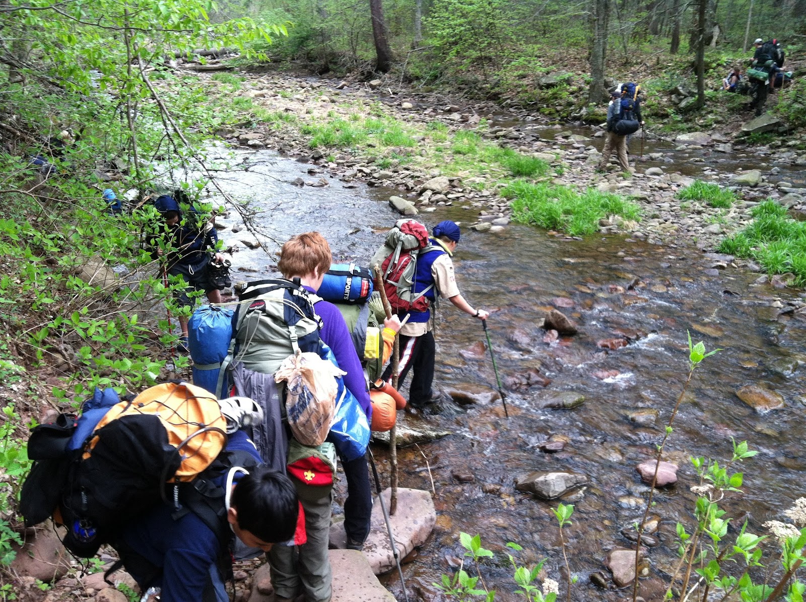
| The first of several stream crossings Saturday morning. |
Saturday morning we were up at 7, fed and on the trail by 9:20. It was slow going! Stream crossings stopped us in our tracks, as boys carefully hopped from rock to rock, passed hiking poles back to those without, and switched from hiking boots to water shoes and back again.
We eventually made it to the intersection of our trail with the Jerry's Run Trail by 11:10, taking 1 hour, 50 minutes to travel about 1.5 miles. We then took Jerry's Run uphill to our Saturday campsite, at the site of an old PATC cabin called the Sexton Cabin. Surprisingly, that distance was about the same, as was the time it took the group. There were no major stream crossings here, but the hike climbed from about 2250 feet up to about 2720 feet.
At the Sexton Cabin site we met a group of younger scouts from our troop, who hiked in on Shenandoah Mountain from the Confederate Breastworks Historic Site, on U.S. 250. The Sexton Cabin site has its own interesting history, which I read that night to the scouts. The history of this site comes from an article
printed in October, 1937 in a newsletter printed by the Potomac Appalachian
Trail Club. It was written when the
trail club was constructing the cabin on this site, and was based on a story by a
man who had lived here 56 years before that, which takes us back to 1881. That man’s name was George Armstrong.
He said that the original clearing here had been
made probably about a hundred years before that. Jerry Hodges had lived here, and his house
was at the upper clearing, near some Lombardy Poplars that were dying back in
1937. This is the Jerry that gave the
name to the stream: Jerry’s Run. Jerry
planted the poplars, and also planted some apple trees around here. He cleared land so that he could graze stock
animals.
 |
The remains of Sexton Cabin in the foreground,
with the troop tents in the background. |
Armstrong’s family had lived here for three years
when he was young. They built an old
house and a barn in this area. It must
have been much less wooded then than it is now.
He said that back then, bears would take the family’s sheep right out of
the field. To protect the sheep, they
would build a pen that would trap the bear if he went after the sheep. Then the family could shoot the bear before
it killed their sheep.
Armstrong’s father moved the family to this site
because a lumber company owned all this land, but men would come up the
mountain to steal the wood. They would
turn the White Pine into shingles, which they could easily take off of the
mountain. The family living here was
enough to keep these “shingle men” off the mountain. Eventually they gave up and the family moved
back to the valley.
 |
| Photo of Sexton Shelter from 1940's era PATC Newsletter. |
The story of the cabin built here is almost as
complicated. In 1930, the PATC built a
cabin in Shenandoah National Park using money donated by a Dr. Sexton. It was the first cabin built for A.T. hikers
south of New York. In 1937, the Park
Service decided to tear the cabin down.
The PATC wanted to rebuild the Sexton Cabin somewhere else and
eventually decided to place it here.
The cabin was built of chestnut logs. That cabin burned down in 1967 from a fire
that probably started by lightning. The
next year Ray Kisamore, who owned a lumber company in Churchville, hauled in materials the PATC used to build Sexton
# 3 on the same spot on a
sledge using Percheron draft horses. More
than nine tons of material had to be hauled in, and each sledge load weighed
between 1,000 and 1,500 pounds. Hauling about 800 to 1,000 pounds at a time, it
took a month to six weeks to bring everything here.
 |
Sunday morning: hiking up the Jerry's Run trail toward
the Shenandoah Mountain Trail. |
Ray
Kisamore had to build a special sledge to haul the logs on. He came in along the Shenandoah Mountain Trail. When Ramsey’s
Draft was declared a federal wilderness area in 1984, the Forest Service believed
the law required tearing down any structures in federal wilderness areas. They tore down the cabin here, though it was
later determined that existing structures in wilderness areas could stay. Ray
Kisamore was hired to haul out the logs, and reportedly at least one of the
horses that hauled out the timbers had been used to haul the logs in here 17
years earlier. Those timbers are used
today, on the Mutton Top Cabin, which is over by Shenandoah National Park.
 |
| Hugging a tree and the trail along the Road Hollow Trail. |
On Sunday morning, we were back on the trail beginning at 9:50, heading uphill on the Jerry's Run Trail to the Shenandoah Mountain Trail. We took the SMT south out of the wilderness (where a wilderness boundary marker featured scratchings over the word "bicycles" - no doubt by some biker who illegally used the trails in the wilderness). At the junction of the SMT and the Road Hollow Trail, the groups split, with the younger boys continuing back to their cars via the SMT and the older boys taking the Road Hollow Trail back to their trailhead. It is interesting to me, and probably only to me, that we went from one of the oldest trails in this part of the National Forest, the SMT which was built in the 1930's by the CCC, to one of the newest, the Road Hollow Trail. The Road Hollow Trail was built around 1990, 60 years later.
I was hiking "sweep," making sure that all boys stayed in front of me, when some mountain bikers came swiftly (and legally) down the Road Hollow Trail. We slowed them down and warned them of boys ahead around the bend. And the boys learned about sharing "single track" trail with other types of users.
In all, we hiked 4.1 miles on Sunday, taking 2 hours and 40 minutes. Hopefully, the boys learned some lessons that they will use when we take them on a longer trip through the Mt. Rogers area in June. And I hope they developed an appreciation of this wonderful part of the mountains, only about an hour from Charlottesville.